Gać geodata
Gać (Subcarpathian) is a seat of a third-order administrative division; located in Poland in Europe/Warsaw (GMT+2) time zone. With population of 1,550 people, there are 1803 cities with bigger population in this country. Compared to other cities in Poland, 81% of cities are located further ↑North; 89.7% of cities are located further ←West and 62.4% of cities have lower elevation than Gać. Note1


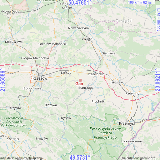
Gać GPS coordinates[2]
50° 1' 36.948" North, 22° 21' 32.328" East
| Map corner | latitude | longitude |
|---|---|---|
| Upper-left | 50.47651°, | 21.65586° |
| Center: | 50.02693°, | 22.35898° |
| Lower-right: | 49.5731°, | 23.06211° |
| Map W x H: | 100.4×100.4 km | = 62.4×62.4mi |
| max Lat: | 54.83135° ⇑81% North |
| Gać: | 50.02693° |
| min Lat: | ⇓19% South 49.21328° |
| min Long | Gać | max Long |
| 14.20249° | 22.35898° | 24.03723° |
| W 89.7%⇐ | ⇒10.3% E |
Elevation
Elevation of Gać is 207 m = 679 ft, and this is 15.6 m = 51 ft above average elevation for this country.
| Max E: |
974 m = 3196 ft | 37.6% |
| Gać | 207 m 679 ft | |
| Avg. | 191.4 m = 628 ft | |
Min E: |
-3 m = -10 ft | 62.4% |
See also: Poland elevation on elevation.city.
Geographical zone
Gać is located in North temperate zone (between Tropic of Cancer and the Arctic Circle). Distance of this North polar circle is 1838.7 km =1142.5 mi to North.| Distance of | km | miles | from Gać |
|---|---|---|---|
| North Pole | 4444.6 | 2761.7 | to North |
| Arctic Circle | 1838.7 | 1142.5 | to North |
| Tropic Cancer | 2956.6 | 1837.1 | to South |
| Equator | 5562.5 | 3456.4 | to South |


Nearby cities:
15 places around Gać: (largest is in red/bold)
• Białobrzegi
8.9 km =5.5 mi,  341°
341°
• Dębów
5.9 km =3.7 mi,  70°
70°
• Głuchów
8.7 km =5.4 mi,  314°
314°
• Husów
7.4 km =4.6 mi,  224°
224°
• Kańczuga
6.1 km =3.8 mi,  142°
142°
• Kosina
5.5 km =3.4 mi, 336°
• Krzeczowice
8.6 km =5.3 mi,  119°
119°
• Markowa
2 km =1.2 mi,  268°
268°
• Nowosielce
5 km =3.1 mi,  47°
47°
• Rogóźno
5.3 km =3.3 mi,  12°
12°
• Siedleczka
7.5 km =4.7 mi,  168°
168°
• Sietesz
4.6 km =2.9 mi,  190°
190°
• Sonina
7.7 km =4.8 mi,  299°
299°
• Urzejowice
7.5 km =4.7 mi,  102°
102°
• Wysoka
7.3 km =4.5 mi,  285°
285°
Sources, notices
• [Note1] Compared only with cities in Poland existing in our database
• [Src1] Map data: © OpenStreetMap contributors (CC-BY-SA)
• [Src2] Other city data from geonames.org with taken over terms of usage.
• [Src3] Geographical zone / Annual Mean Temperature by Robert A. Rohde @ Wikipedia
