Korczyna geodata
Korczyna (Subcarpathian) is a seat of a third-order administrative division; located in Poland in Europe/Warsaw (GMT+2) time zone. With population of 6,100 people, there are 595 cities with bigger population in this country. Compared to other cities in Poland, 94.2% of cities are located further ↑North; 82.4% of cities are located further ←West and 85.4% of cities have lower elevation than Korczyna. Note1


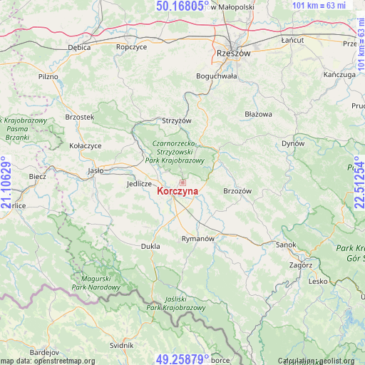
Korczyna GPS coordinates[2]
49° 42' 55.98" North, 21° 48' 33.876" East
| Map corner | latitude | longitude |
|---|---|---|
| Upper-left | 50.16805°, | 21.10629° |
| Center: | 49.71555°, | 21.80941° |
| Lower-right: | 49.25879°, | 22.51254° |
| Map W x H: | 101.1×101.1 km | = 62.8×62.8mi |
| max Lat: | 54.83135° ⇑94.2% North |
| Korczyna: | 49.71555° |
| min Lat: | ⇓5.8% South 49.21328° |
| min Long | Korczyna | max Long |
| 14.20249° | 21.80941° | 24.03723° |
| W 82.4%⇐ | ⇒17.6% E |
Elevation
Elevation of Korczyna is 292 m = 958 ft, and this is 100.6 m = 330 ft above average elevation for this country.
| Max E: |
974 m = 3196 ft | 14.6% |
| Korczyna | 292 m 958 ft | |
| Avg. | 191.4 m = 628 ft | |
Min E: |
-3 m = -10 ft | 85.4% |
See also: Poland elevation on elevation.city.
Geographical zone
Korczyna is located in North temperate zone (between Tropic of Cancer and the Arctic Circle). Distance of this North polar circle is 1873.3 km =1164 mi to North.| Distance of | km | miles | from Korczyna |
|---|---|---|---|
| North Pole | 4479.2 | 2783.2 | to North |
| Arctic Circle | 1873.3 | 1164 | to North |
| Tropic Cancer | 2921.9 | 1815.6 | to South |
| Equator | 5527.9 | 3434.9 | to South |


Nearby cities:
15 places around Korczyna: (largest is in red/bold)
• Blizne
12.5 km =7.8 mi,  70°
70°
• Chorkówka
12.5 km =7.8 mi,  232°
232°
• Haczów
8.8 km =5.5 mi,  133°
133°
• Jabłonica Polska
6.8 km =4.2 mi,  106°
106°
• Jasienica Rosielna
10.3 km =6.4 mi, 67°
• Jedlicze
11.5 km =7.1 mi,  271°
271°
• Krasna
7.4 km =4.6 mi,  25°
25°
• Krosno
4.1 km =2.5 mi,  223°
223°
• Krościenko Wyżne
4.3 km =2.7 mi,  160°
160°
• Malinówka
8.8 km =5.5 mi,  103°
103°
• Miejsce Piastowe
9.2 km =5.7 mi,  189°
189°
• Odrzykoń
5.7 km =3.5 mi,  299°
299°
• Orzechówka
9.9 km =6.2 mi,  80°
80°
• Wojaszówka
12.1 km =7.5 mi, 304°
• Zmiennica
12.1 km =7.5 mi, 111°
Sources, notices
• [Note1] Compared only with cities in Poland existing in our database
• [Src1] Map data: © OpenStreetMap contributors (CC-BY-SA)
• [Src2] Other city data from geonames.org with taken over terms of usage.
• [Src3] Geographical zone / Annual Mean Temperature by Robert A. Rohde @ Wikipedia
