Łaszczów geodata
Łaszczów (Lublin) is a seat of a third-order administrative division; located in Poland in Europe/Warsaw (GMT+2) time zone. With population of 2,341 people, there are 1307 cities with bigger population in this country. Compared to other cities in Poland, 66.6% of cities are located further ↑North; 99.5% of cities are located further ←West and 61% of cities have lower elevation than Łaszczów. Note1


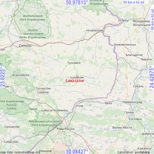
Łaszczów GPS coordinates[2]
50° 31' 59.952" North, 23° 43' 32.232" East
| Map corner | latitude | longitude |
|---|---|---|
| Upper-left | 50.97813°, | 23.0225° |
| Center: | 50.53332°, | 23.72562° |
| Lower-right: | 50.08427°, | 24.42875° |
| Map W x H: | 99.4×99.4 km | = 61.8×61.8mi |
| max Lat: | 54.83135° ⇑66.6% North |
| Łaszczów: | 50.53332° |
| min Lat: | ⇓33.4% South 49.21328° |
| min Long | Łaszczów | max Long |
| 14.20249° | 23.72562° | 24.03723° |
| W 99.5%⇐ | ⇒0.5% E |
Elevation
Elevation of Łaszczów is 203 m = 666 ft, and this is 11.6 m = 38 ft above average elevation for this country.
| Max E: |
974 m = 3196 ft | 39% |
| Łaszczów | 203 m 666 ft | |
| Avg. | 191.4 m = 628 ft | |
Min E: |
-3 m = -10 ft | 61% |
See also: Poland elevation on elevation.city.
Geographical zone
Łaszczów is located in North temperate zone (between Tropic of Cancer and the Arctic Circle). Distance of this North polar circle is 1782.4 km =1107.5 mi to North.| Distance of | km | miles | from Łaszczów |
|---|---|---|---|
| North Pole | 4388.3 | 2726.8 | to North |
| Arctic Circle | 1782.4 | 1107.5 | to North |
| Tropic Cancer | 3012.9 | 1872.1 | to South |
| Equator | 5618.8 | 3491.4 | to South |


Nearby cities:
15 places around Łaszczów: (largest is in red/bold)
• Dołhobyczów
22.7 km =14.1 mi,  75°
75°
• Jarczów
15.6 km =9.7 mi,  219°
219°
• Komarów-Osada
20.5 km =12.7 mi,  301°
301°
• Krynice
25 km =15.5 mi,  283°
283°
• Lubycza Królewska
25.9 km =16.1 mi,  214°
214°
• Michałów
8.8 km =5.5 mi, 280°
• Mircze
17.8 km =11.1 mi,  42°
42°
• Rachanie
12.6 km =7.8 mi,  272°
272°
• Rogóźno
24.9 km =15.5 mi,  252°
252°
• Tarnawatka
23.3 km =14.5 mi, 269°
• Telatyn
8.1 km =5 mi,  94°
94°
• Tomaszów Lubelski
23.9 km =14.9 mi, 246°
• Tyszowce
9.5 km =5.9 mi,  348°
348°
• Ulhówek
10.7 km =6.6 mi,  150°
150°
• Werbkowice
24.7 km =15.3 mi,  6°
6°
Sources, notices
• [Note1] Compared only with cities in Poland existing in our database
• [Src1] Map data: © OpenStreetMap contributors (CC-BY-SA)
• [Src2] Other city data from geonames.org with taken over terms of usage.
• [Src3] Geographical zone / Annual Mean Temperature by Robert A. Rohde @ Wikipedia
