Leżachów geodata
Leżachów (Subcarpathian) is a populated place; located in Poland in Europe/Warsaw (GMT+2) time zone. With population of 523 people, there are 3473 cities with bigger population in this country. Compared to other cities in Poland, 76.3% of cities are located further ↑North; 93% of cities are located further ←West and 51.2% of cities have lower elevation than Leżachów. Note1


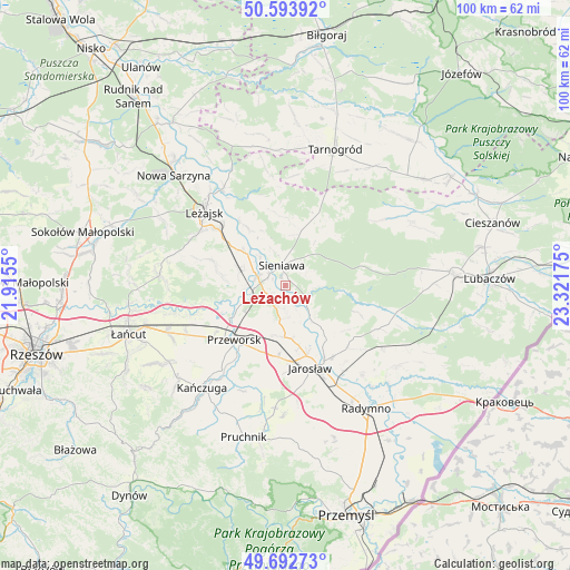
Leżachów GPS coordinates[2]
50° 8' 43.62" North, 22° 37' 7.032" East
| Map corner | latitude | longitude |
|---|---|---|
| Upper-left | 50.59392°, | 21.9155° |
| Center: | 50.14545°, | 22.61862° |
| Lower-right: | 49.69273°, | 23.32175° |
| Map W x H: | 100.2×100.2 km | = 62.3×62.3mi |
| max Lat: | 54.83135° ⇑76.3% North |
| Leżachów: | 50.14545° |
| min Lat: | ⇓23.7% South 49.21328° |
| min Long | Leżachów | max Long |
| 14.20249° | 22.61862° | 24.03723° |
| W 93%⇐ | ⇒7% E |
Elevation
Elevation of Leżachów is 175 m = 574 ft, and this is 16.4 m = 54 ft below average elevation for this country.
| Max E: |
974 m = 3196 ft | 48.8% |
| Avg. | 191.4 m = 628 ft | |
| Leżachów | 175 m = 574 ft | |
Min E: |
-3 m = -10 ft | 51.2% |
See also: Poland elevation on elevation.city.
Geographical zone
Leżachów is located in North temperate zone (between Tropic of Cancer and the Arctic Circle). Distance of this North polar circle is 1825.5 km =1134.3 mi to North.| Distance of | km | miles | from Leżachów |
|---|---|---|---|
| North Pole | 4431.4 | 2753.5 | to North |
| Arctic Circle | 1825.5 | 1134.3 | to North |
| Tropic Cancer | 2969.7 | 1845.3 | to South |
| Equator | 5575.7 | 3464.6 | to South |


Nearby cities:
15 places around Leżachów: (largest is in red/bold)
• Dębno
9.2 km =5.7 mi,  309°
309°
• Gorliczyna
11.1 km =6.9 mi,  237°
237°
• Gorzyce
3.4 km =2.1 mi, 235°
• Grodzisko Dolne
11.3 km =7 mi,  279°
279°
• Jagiełła
6.5 km =4 mi,  210°
210°
• Mirocin
12.3 km =7.6 mi,  201°
201°
• Piskorowice
11.9 km =7.4 mi,  327°
327°
• Rozbórz
11.2 km =7 mi, 207°
• Sieniawa
3.7 km =2.3 mi,  349°
349°
• Tryńcza
5.2 km =3.2 mi,  289°
289°
• Ubieszyn
3.5 km =2.2 mi, 307°
• Ujezna
8.9 km =5.5 mi,  193°
193°
• Wiązownica
9.6 km =6 mi,  138°
138°
• Wylewa
5.1 km =3.2 mi,  3°
3°
• Wólka Pełkińska
5.6 km =3.5 mi,  176°
176°
Sources, notices
• [Note1] Compared only with cities in Poland existing in our database
• [Src1] Map data: © OpenStreetMap contributors (CC-BY-SA)
• [Src2] Other city data from geonames.org with taken over terms of usage.
• [Src3] Geographical zone / Annual Mean Temperature by Robert A. Rohde @ Wikipedia
