Piskorowice geodata
Piskorowice (Subcarpathian) is a populated place; located in Poland in Europe/Warsaw (GMT+2) time zone. With population of 1,116 people, there are 2286 cities with bigger population in this country. Compared to other cities in Poland, 73.6% of cities are located further ↑North; 92% of cities are located further ←West and 50.8% of cities have higher elevation than Piskorowice. Note1


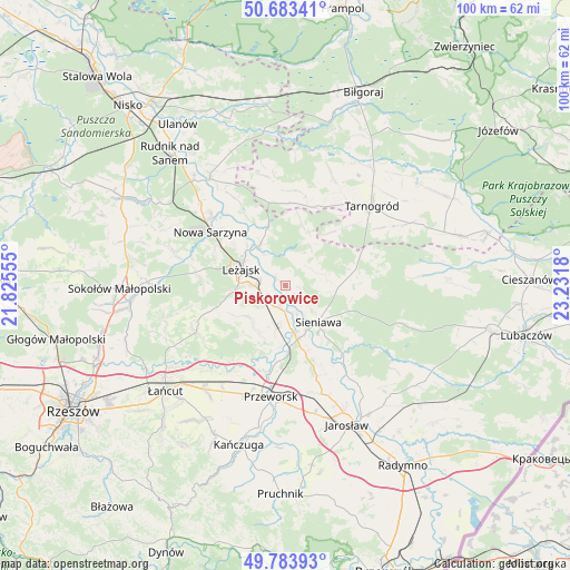
Piskorowice GPS coordinates[2]
50° 14' 8.844" North, 22° 31' 43.212" East
| Map corner | latitude | longitude |
|---|---|---|
| Upper-left | 50.68341°, | 21.82555° |
| Center: | 50.23579°, | 22.52867° |
| Lower-right: | 49.78393°, | 23.2318° |
| Map W x H: | 100×100 km | = 62.1×62.1mi |
| max Lat: | 54.83135° ⇑73.6% North |
| Piskorowice: | 50.23579° |
| min Lat: | ⇓26.4% South 49.21328° |
| min Long | Piskorowice | max Long |
| 14.20249° | 22.52867° | 24.03723° |
| W 92%⇐ | ⇒8% E |
Elevation
Elevation of Piskorowice is 170 m = 558 ft, and this is 21.4 m = 70 ft below average elevation for this country.
| Max E: |
974 m = 3196 ft | 50.8% |
| Avg. | 191.4 m = 628 ft | |
| Piskorowice | 170 m = 558 ft | |
Min E: |
-3 m = -10 ft | 49.2% |
See also: Poland elevation on elevation.city.
Geographical zone
Piskorowice is located in North temperate zone (between Tropic of Cancer and the Arctic Circle). Distance of this North polar circle is 1815.5 km =1128.1 mi to North.| Distance of | km | miles | from Piskorowice |
|---|---|---|---|
| North Pole | 4421.4 | 2747.3 | to North |
| Arctic Circle | 1815.5 | 1128.1 | to North |
| Tropic Cancer | 2979.8 | 1851.6 | to South |
| Equator | 5585.7 | 3470.8 | to South |


Nearby cities:
15 places around Piskorowice: (largest is in red/bold)
• Dębno
4.3 km =2.7 mi,  189°
189°
• Giedlarowa
8.8 km =5.5 mi,  263°
263°
• Grodzisko Dolne
9.4 km =5.8 mi,  209°
209°
• Grodzisko Górne
8.4 km =5.2 mi,  229°
229°
• Kuryłówka
8.4 km =5.2 mi,  327°
327°
• Leżachów
11.9 km =7.4 mi,  147°
147°
• Leżajsk
8.3 km =5.2 mi,  290°
290°
• Przychojec
11.4 km =7.1 mi,  307°
307°
• Sieniawa
8.6 km =5.3 mi,  138°
138°
• Stare Miasto
9.2 km =5.7 mi, 309°
• Tryńcza
8.5 km =5.3 mi,  169°
169°
• Ubieszyn
8.7 km =5.4 mi,  155°
155°
• Wierzawice
5.5 km =3.4 mi,  270°
270°
• Wylewa
8.3 km =5.2 mi,  126°
126°
• Wólka Grodziska
10.4 km =6.5 mi,  239°
239°
Sources, notices
• [Note1] Compared only with cities in Poland existing in our database
• [Src1] Map data: © OpenStreetMap contributors (CC-BY-SA)
• [Src2] Other city data from geonames.org with taken over terms of usage.
• [Src3] Geographical zone / Annual Mean Temperature by Robert A. Rohde @ Wikipedia
