Dębno geodata
Dębno (Subcarpathian) is a populated place; located in Poland in Europe/Warsaw (GMT+2) time zone. With population of 1,500 people, there are 1837 cities with bigger population in this country. Compared to other cities in Poland, 74.5% of cities are located further ↑North; 92% of cities are located further ←West and 50.6% of cities have lower elevation than Dębno. Note1


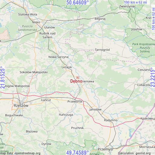
Dębno GPS coordinates[2]
50° 11' 53.196" North, 22° 31' 6.132" East
| Map corner | latitude | longitude |
|---|---|---|
| Upper-left | 50.64609°, | 21.81525° |
| Center: | 50.19811°, | 22.51837° |
| Lower-right: | 49.74589°, | 23.2215° |
| Map W x H: | 100.1×100.1 km | = 62.2×62.2mi |
| max Lat: | 54.83135° ⇑74.5% North |
| Dębno: | 50.19811° |
| min Lat: | ⇓25.5% South 49.21328° |
| min Long | Dębno | max Long |
| 14.20249° | 22.51837° | 24.03723° |
| W 92%⇐ | ⇒8% E |
Elevation
Elevation of Dębno is 173 m = 568 ft, and this is 18.4 m = 60 ft below average elevation for this country.
| Max E: |
974 m = 3196 ft | 49.4% |
| Avg. | 191.4 m = 628 ft | |
| Dębno | 173 m = 568 ft | |
Min E: |
-3 m = -10 ft | 50.6% |
See also: Poland elevation on elevation.city.
Geographical zone
Dębno is located in North temperate zone (between Tropic of Cancer and the Arctic Circle). Distance of this North polar circle is 1819.7 km =1130.7 mi to North.| Distance of | km | miles | from Dębno |
|---|---|---|---|
| North Pole | 4425.6 | 2749.9 | to North |
| Arctic Circle | 1819.7 | 1130.7 | to North |
| Tropic Cancer | 2975.6 | 1849 | to South |
| Equator | 5581.5 | 3468.2 | to South |


Nearby cities:
15 places around Dębno: (largest is in red/bold)
• Giedlarowa
8.6 km =5.3 mi,  291°
291°
• Gorzyce
8.9 km =5.5 mi,  150°
150°
• Grodzisko Dolne
5.6 km =3.5 mi,  224°
224°
• Grodzisko Górne
5.9 km =3.7 mi,  257°
257°
• Kuryłówka
11.9 km =7.4 mi,  341°
341°
• Leżachów
9.2 km =5.7 mi,  129°
129°
• Leżajsk
10.1 km =6.3 mi,  315°
315°
• Piskorowice
4.3 km =2.7 mi,  9°
9°
• Sieniawa
6.9 km =4.3 mi,  109°
109°
• Stare Miasto
11.9 km =7.4 mi,  327°
327°
• Tryńcza
4.7 km =2.9 mi, 151°
• Ubieszyn
5.8 km =3.6 mi, 130°
• Wierzawice
6.4 km =4 mi,  311°
311°
• Wylewa
7.5 km =4.7 mi,  95°
95°
• Wólka Grodziska
8.3 km =5.2 mi, 263°
Sources, notices
• [Note1] Compared only with cities in Poland existing in our database
• [Src1] Map data: © OpenStreetMap contributors (CC-BY-SA)
• [Src2] Other city data from geonames.org with taken over terms of usage.
• [Src3] Geographical zone / Annual Mean Temperature by Robert A. Rohde @ Wikipedia
