Kruklanki geodata
Kruklanki (Warmia-Masuria) is a populated place; located in Poland in Europe/Warsaw (GMT+2) time zone. With population of 1,100 people, there are 2307 cities with bigger population in this country. Compared to other cities in Poland, 95.1% of cities are located further ↓South; 83.7% of cities are located further ←West and 66.4% of cities have higher elevation than Kruklanki. Note1


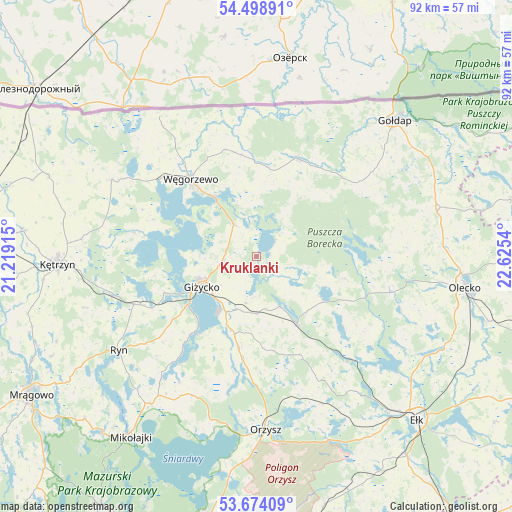
Kruklanki GPS coordinates[2]
54° 5' 18.78" North, 21° 55' 20.172" East
| Map corner | latitude | longitude |
|---|---|---|
| Upper-left | 54.49891°, | 21.21915° |
| Center: | 54.08855°, | 21.92227° |
| Lower-right: | 53.67409°, | 22.6254° |
| Map W x H: | 91.7×91.7 km | = 57×57mi |
| max Lat: | 54.83135° ⇑4.9% North |
| Kruklanki: | 54.08855° |
| min Lat: | ⇓95.1% South 49.21328° |
| min Long | Kruklanki | max Long |
| 14.20249° | 21.92227° | 24.03723° |
| W 83.7%⇐ | ⇒16.3% E |
Elevation
Elevation of Kruklanki is 129 m = 423 ft, and this is 62.4 m = 205 ft below average elevation for this country.
| Max E: |
974 m = 3196 ft | 66.4% |
| Avg. | 191.4 m = 628 ft | |
| Kruklanki | 129 m = 423 ft | |
Min E: |
-3 m = -10 ft | 33.6% |
See also: Poland elevation on elevation.city.
Geographical zone
Kruklanki is located in North temperate zone (between Tropic of Cancer and the Arctic Circle). Distance of this North polar circle is 1387.1 km =861.9 mi to North.| Distance of | km | miles | from Kruklanki |
|---|---|---|---|
| North Pole | 3993 | 2481.1 | to North |
| Arctic Circle | 1387.1 | 861.9 | to North |
| Tropic Cancer | 3408.2 | 2117.8 | to South |
| Equator | 6014.1 | 3737 | to South |


Nearby cities:
15 places around Kruklanki: (largest is in red/bold)
• Banie Mazurskie
19.1 km =11.9 mi,  22°
22°
• Gierłoż
27.8 km =17.3 mi,  268°
268°
• Giżycko
11.7 km =7.3 mi,  241°
241°
• Gołdap
34.7 km =21.6 mi,  45°
45°
• Grabowo
25.7 km =16 mi, 53°
• Kowale Oleckie
33.3 km =20.7 mi,  75°
75°
• Miłki
16.4 km =10.2 mi,  188°
188°
• Orzysz
31.1 km =19.3 mi,  176°
176°
• Pozezdrze
7.2 km =4.5 mi,  325°
325°
• Ryn
29.7 km =18.5 mi, 235°
• Srokowo
29.5 km =18.3 mi,  298°
298°
• Stare Juchy
24.8 km =15.4 mi,  138°
138°
• Swiętajno
27.6 km =17.1 mi,  110°
110°
• Wydminy
13.9 km =8.6 mi,  148°
148°
• Węgorzewo
18.6 km =11.6 mi,  319°
319°
Sources, notices
• [Note1] Compared only with cities in Poland existing in our database
• [Src1] Map data: © OpenStreetMap contributors (CC-BY-SA)
• [Src2] Other city data from geonames.org with taken over terms of usage.
• [Src3] Geographical zone / Annual Mean Temperature by Robert A. Rohde @ Wikipedia
