Wydminy geodata
Wydminy (Warmia-Masuria) is a populated place; located in Poland in Europe/Warsaw (GMT+2) time zone. With population of 2,448 people, there are 1271 cities with bigger population in this country. Compared to other cities in Poland, 93.9% of cities are located further ↓South; 85.2% of cities are located further ←West and 59.9% of cities have higher elevation than Wydminy. Note1


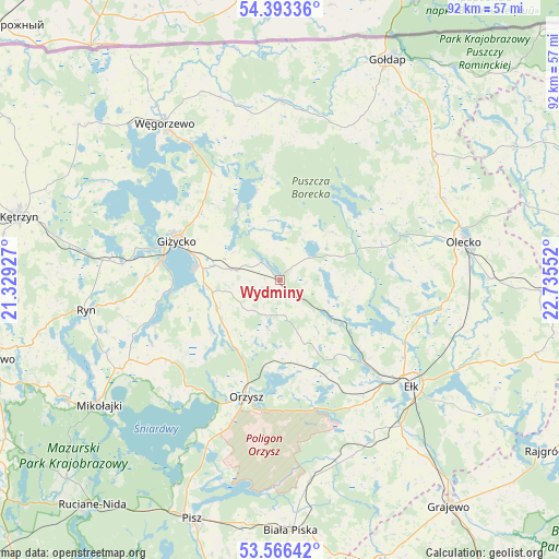
Wydminy GPS coordinates[2]
53° 58' 54.984" North, 22° 1' 56.604" East
| Map corner | latitude | longitude |
|---|---|---|
| Upper-left | 54.39336°, | 21.32927° |
| Center: | 53.98194°, | 22.03239° |
| Lower-right: | 53.56642°, | 22.73552° |
| Map W x H: | 91.9×91.9 km | = 57.1×57.1mi |
| max Lat: | 54.83135° ⇑6.1% North |
| Wydminy: | 53.98194° |
| min Lat: | ⇓93.9% South 49.21328° |
| min Long | Wydminy | max Long |
| 14.20249° | 22.03239° | 24.03723° |
| W 85.2%⇐ | ⇒14.8% E |
Elevation
Elevation of Wydminy is 147 m = 482 ft, and this is 44.4 m = 146 ft below average elevation for this country.
| Max E: |
974 m = 3196 ft | 59.9% |
| Avg. | 191.4 m = 628 ft | |
| Wydminy | 147 m = 482 ft | |
Min E: |
-3 m = -10 ft | 40.1% |
See also: Poland elevation on elevation.city.
Geographical zone
Wydminy is located in North temperate zone (between Tropic of Cancer and the Arctic Circle). Distance of this North polar circle is 1398.9 km =869.2 mi to North.| Distance of | km | miles | from Wydminy |
|---|---|---|---|
| North Pole | 4004.8 | 2488.5 | to North |
| Arctic Circle | 1398.9 | 869.2 | to North |
| Tropic Cancer | 3396.3 | 2110.4 | to South |
| Equator | 6002.2 | 3729.6 | to South |


Nearby cities:
15 places around Wydminy: (largest is in red/bold)
• Banie Mazurskie
29.4 km =18.3 mi,  0°
0°
• Ełk
27.7 km =17.2 mi,  128°
128°
• Giżycko
18.6 km =11.6 mi,  289°
289°
• Grabowo
30.3 km =18.8 mi,  26°
26°
• Kowale Oleckie
32.2 km =20 mi,  51°
51°
• Kruklanki
13.9 km =8.6 mi,  328°
328°
• Miłki
10.7 km =6.6 mi,  246°
246°
• Olecko
31.5 km =19.6 mi,  79°
79°
• Orzysz
19.9 km =12.4 mi,  196°
196°
• Pozezdrze
21 km =13 mi, 327°
• Ryn
32.2 km =20 mi,  261°
261°
• Stare Juchy
11.4 km =7.1 mi, 125°
• Swiętajno
18.8 km =11.7 mi, 83°
• Wieliczki
34.6 km =21.5 mi,  89°
89°
• Węgorzewo
32.3 km =20.1 mi,  323°
323°
Sources, notices
• [Note1] Compared only with cities in Poland existing in our database
• [Src1] Map data: © OpenStreetMap contributors (CC-BY-SA)
• [Src2] Other city data from geonames.org with taken over terms of usage.
• [Src3] Geographical zone / Annual Mean Temperature by Robert A. Rohde @ Wikipedia
