Kowale Oleckie geodata
Kowale Oleckie (Warmia-Masuria) is a populated place; located in Poland in Europe/Warsaw (GMT+2) time zone. With population of 2,209 people, there are 1354 cities with bigger population in this country. Compared to other cities in Poland, 95.9% of cities are located further ↓South; 90.5% of cities are located further ←West and 61% of cities have lower elevation than Kowale Oleckie. Note1


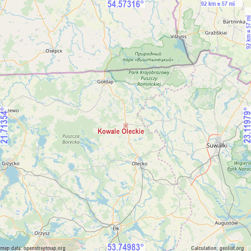
Kowale Oleckie GPS coordinates[2]
54° 9' 48.744" North, 22° 24' 59.976" East
| Map corner | latitude | longitude |
|---|---|---|
| Upper-left | 54.57316°, | 21.71354° |
| Center: | 54.16354°, | 22.41666° |
| Lower-right: | 53.74983°, | 23.11979° |
| Map W x H: | 91.5×91.5 km | = 56.9×56.9mi |
| max Lat: | 54.83135° ⇑4.1% North |
| Kowale Oleckie: | 54.16354° |
| min Lat: | ⇓95.9% South 49.21328° |
| min Long | Kowale Oleckie | max Long |
| 14.20249° | 22.41666° | 24.03723° |
| W 90.5%⇐ | ⇒9.5% E |
Elevation
Elevation of Kowale Oleckie is 203 m = 666 ft, and this is 11.6 m = 38 ft above average elevation for this country.
| Max E: |
974 m = 3196 ft | 39% |
| Kowale Oleckie | 203 m 666 ft | |
| Avg. | 191.4 m = 628 ft | |
Min E: |
-3 m = -10 ft | 61% |
See also: Poland elevation on elevation.city.
Geographical zone
Kowale Oleckie is located in North temperate zone (between Tropic of Cancer and the Arctic Circle). Distance of this North polar circle is 1378.8 km =856.7 mi to North.| Distance of | km | miles | from Kowale Oleckie |
|---|---|---|---|
| North Pole | 3984.6 | 2475.9 | to North |
| Arctic Circle | 1378.8 | 856.7 | to North |
| Tropic Cancer | 3416.5 | 2122.9 | to South |
| Equator | 6022.4 | 3742.1 | to South |


Nearby cities:
15 places around Kowale Oleckie: (largest is in red/bold)
• Bakałarzewo
17.2 km =10.7 mi,  116°
116°
• Banie Mazurskie
26.4 km =16.4 mi,  290°
290°
• Dubeninki
16.7 km =10.4 mi,  33°
33°
• Filipów
13.4 km =8.3 mi,  81°
81°
• Gołdap
17.5 km =10.9 mi,  335°
335°
• Grabowo
13.4 km =8.3 mi,  301°
301°
• Jeleniewo
32.6 km =20.3 mi, 81°
• Kruklanki
33.3 km =20.7 mi,  255°
255°
• Olecko
15.6 km =9.7 mi,  157°
157°
• Przerośl
18.5 km =11.5 mi,  57°
57°
• Raczki
31 km =19.3 mi,  129°
129°
• Stare Juchy
31.2 km =19.4 mi,  210°
210°
• Swiętajno
19.1 km =11.9 mi,  199°
199°
• Wieliczki
22 km =13.7 mi,  154°
154°
• Wydminy
32.2 km =20 mi,  231°
231°
Sources, notices
• [Note1] Compared only with cities in Poland existing in our database
• [Src1] Map data: © OpenStreetMap contributors (CC-BY-SA)
• [Src2] Other city data from geonames.org with taken over terms of usage.
• [Src3] Geographical zone / Annual Mean Temperature by Robert A. Rohde @ Wikipedia
