Gierłoż geodata
Gierłoż (Warmia-Masuria) is a populated place; located in Poland in Europe/Warsaw (GMT+2) time zone. With population of 28,351 people, there are 174 cities with bigger population in this country. Compared to other cities in Poland, 95% of cities are located further ↓South; 79.1% of cities are located further ←West and 63.4% of cities have higher elevation than Gierłoż. Note1


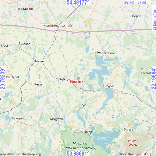
Gierłoż GPS coordinates[2]
54° 4' 52.824" North, 21° 29' 43.836" East
| Map corner | latitude | longitude |
|---|---|---|
| Upper-left | 54.49177°, | 20.79239° |
| Center: | 54.08134°, | 21.49551° |
| Lower-right: | 53.66681°, | 22.19864° |
| Map W x H: | 91.7×91.7 km | = 57×57mi |
| max Lat: | 54.83135° ⇑5% North |
| Gierłoż: | 54.08134° |
| min Lat: | ⇓95% South 49.21328° |
| min Long | Gierłoż | max Long |
| 14.20249° | 21.49551° | 24.03723° |
| W 79.1%⇐ | ⇒20.9% E |
Elevation
Elevation of Gierłoż is 138 m = 453 ft, and this is 53.4 m = 175 ft below average elevation for this country.
| Max E: |
974 m = 3196 ft | 63.4% |
| Avg. | 191.4 m = 628 ft | |
| Gierłoż | 138 m = 453 ft | |
Min E: |
-3 m = -10 ft | 36.6% |
See also: Poland elevation on elevation.city.
Geographical zone
Gierłoż is located in North temperate zone (between Tropic of Cancer and the Arctic Circle). Distance of this North polar circle is 1387.9 km =862.4 mi to North.| Distance of | km | miles | from Gierłoż |
|---|---|---|---|
| North Pole | 3993.8 | 2481.6 | to North |
| Arctic Circle | 1387.9 | 862.4 | to North |
| Tropic Cancer | 3407.4 | 2117.3 | to South |
| Equator | 6013.3 | 3736.5 | to South |


Nearby cities:
15 places around Gierłoż: (largest is in red/bold)
• Baranowo
28.5 km =17.7 mi,  186°
186°
• Barciany
18 km =11.2 mi,  329°
329°
• Giżycko
18.2 km =11.3 mi,  105°
105°
• Kolno
34 km =21.1 mi,  253°
253°
• Korsze
25.2 km =15.7 mi,  293°
293°
• Kruklanki
27.8 km =17.3 mi,  88°
88°
• Kętrzyn
7.9 km =4.9 mi,  266°
266°
• Mikołajki
31.3 km =19.4 mi,  171°
171°
• Miłki
29.6 km =18.4 mi,  121°
121°
• Mrągowo
27.1 km =16.8 mi,  207°
207°
• Pozezdrze
24.7 km =15.3 mi,  74°
74°
• Reszel
23.1 km =14.4 mi,  261°
261°
• Ryn
16.3 km =10.1 mi, 168°
• Srokowo
14.9 km =9.3 mi,  6°
6°
• Węgorzewo
21.7 km =13.5 mi,  46°
46°
Sources, notices
• [Note1] Compared only with cities in Poland existing in our database
• [Src1] Map data: © OpenStreetMap contributors (CC-BY-SA)
• [Src2] Other city data from geonames.org with taken over terms of usage.
• [Src3] Geographical zone / Annual Mean Temperature by Robert A. Rohde @ Wikipedia
