Stare Juchy geodata
Stare Juchy (Warmia-Masuria) is a populated place; located in Poland in Europe/Warsaw (GMT+2) time zone. With population of 1,800 people, there are 1605 cities with bigger population in this country. Compared to other cities in Poland, 93.5% of cities are located further ↓South; 87.1% of cities are located further ←West and 64.1% of cities have higher elevation than Stare Juchy. Note1


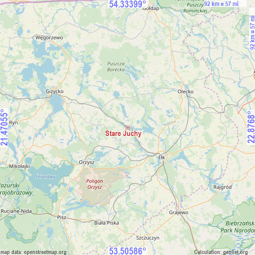
Stare Juchy GPS coordinates[2]
53° 55' 19.128" North, 22° 10' 25.212" East
| Map corner | latitude | longitude |
|---|---|---|
| Upper-left | 54.33399°, | 21.47055° |
| Center: | 53.92198°, | 22.17367° |
| Lower-right: | 53.50586°, | 22.8768° |
| Map W x H: | 92.1×92.1 km | = 57.2×57.2mi |
| max Lat: | 54.83135° ⇑6.5% North |
| Stare Juchy: | 53.92198° |
| min Lat: | ⇓93.5% South 49.21328° |
| min Long | Stare Juchy | max Long |
| 14.20249° | 22.17367° | 24.03723° |
| W 87.1%⇐ | ⇒12.9% E |
Elevation
Elevation of Stare Juchy is 136 m = 446 ft, and this is 55.4 m = 182 ft below average elevation for this country.
| Max E: |
974 m = 3196 ft | 64.1% |
| Avg. | 191.4 m = 628 ft | |
| Stare Juchy | 136 m = 446 ft | |
Min E: |
-3 m = -10 ft | 35.9% |
See also: Poland elevation on elevation.city.
Geographical zone
Stare Juchy is located in North temperate zone (between Tropic of Cancer and the Arctic Circle). Distance of this North polar circle is 1405.6 km =873.4 mi to North.| Distance of | km | miles | from Stare Juchy |
|---|---|---|---|
| North Pole | 4011.5 | 2492.6 | to North |
| Arctic Circle | 1405.6 | 873.4 | to North |
| Tropic Cancer | 3389.6 | 2106.2 | to South |
| Equator | 5995.6 | 3725.5 | to South |


Nearby cities:
15 places around Stare Juchy: (largest is in red/bold)
• Biała Piska
35.2 km =21.9 mi,  191°
191°
• Ełk
16.3 km =10.1 mi,  129°
129°
• Giżycko
29.7 km =18.5 mi,  295°
295°
• Grabowo
34.1 km =21.2 mi,  7°
7°
• Kalinowo
33.1 km =20.6 mi,  99°
99°
• Kowale Oleckie
31.2 km =19.4 mi,  30°
30°
• Kruklanki
24.8 km =15.4 mi,  318°
318°
• Miłki
19.1 km =11.9 mi,  277°
277°
• Olecko
25.1 km =15.6 mi,  60°
60°
• Orzysz
19.4 km =12.1 mi,  229°
229°
• Pozezdrze
31.9 km =19.8 mi, 319°
• Prostki
30 km =18.6 mi,  145°
145°
• Swiętajno
13 km =8.1 mi,  46°
46°
• Wieliczki
26.3 km =16.3 mi,  74°
74°
• Wydminy
11.4 km =7.1 mi,  305°
305°
Sources, notices
• [Note1] Compared only with cities in Poland existing in our database
• [Src1] Map data: © OpenStreetMap contributors (CC-BY-SA)
• [Src2] Other city data from geonames.org with taken over terms of usage.
• [Src3] Geographical zone / Annual Mean Temperature by Robert A. Rohde @ Wikipedia
