Grabowo geodata
Grabowo (Warmia-Masuria) is a populated place; located in Poland in Europe/Warsaw (GMT+2) time zone. With population of 645 people, there are 3180 cities with bigger population in this country. Compared to other cities in Poland, 96.6% of cities are located further ↓South; 87.8% of cities are located further ←West and 66.4% of cities have lower elevation than Grabowo. Note1


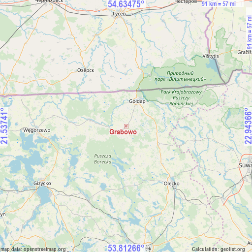
Grabowo GPS coordinates[2]
54° 13' 32.7" North, 22° 14' 25.908" East
| Map corner | latitude | longitude |
|---|---|---|
| Upper-left | 54.63475°, | 21.53741° |
| Center: | 54.22575°, | 22.24053° |
| Lower-right: | 53.81266°, | 22.94366° |
| Map W x H: | 91.4×91.4 km | = 56.8×56.8mi |
| max Lat: | 54.83135° ⇑3.4% North |
| Grabowo: | 54.22575° |
| min Lat: | ⇓96.6% South 49.21328° |
| min Long | Grabowo | max Long |
| 14.20249° | 22.24053° | 24.03723° |
| W 87.8%⇐ | ⇒12.2% E |
Elevation
Elevation of Grabowo is 218 m = 715 ft, and this is 26.6 m = 87 ft above average elevation for this country.
| Max E: |
974 m = 3196 ft | 33.6% |
| Grabowo | 218 m 715 ft | |
| Avg. | 191.4 m = 628 ft | |
Min E: |
-3 m = -10 ft | 66.4% |
See also: Poland elevation on elevation.city.
Geographical zone
Grabowo is located in North temperate zone (between Tropic of Cancer and the Arctic Circle). Distance of this North polar circle is 1371.8 km =852.4 mi to North.| Distance of | km | miles | from Grabowo |
|---|---|---|---|
| North Pole | 3977.7 | 2471.6 | to North |
| Arctic Circle | 1371.8 | 852.4 | to North |
| Tropic Cancer | 3423.4 | 2127.2 | to South |
| Equator | 6029.3 | 3746.4 | to South |


Nearby cities:
15 places around Grabowo: (largest is in red/bold)
• Bakałarzewo
30.5 km =19 mi,  118°
118°
• Banie Mazurskie
13.5 km =8.4 mi,  279°
279°
• Dubeninki
21.8 km =13.5 mi,  71°
71°
• Filipów
25.2 km =15.7 mi,  101°
101°
• Gołdap
9.8 km =6.1 mi,  24°
24°
• Kowale Oleckie
13.4 km =8.3 mi, 121°
• Kruklanki
25.7 km =16 mi,  233°
233°
• Olecko
27.5 km =17.1 mi,  140°
140°
• Pozezdrze
26.5 km =16.5 mi,  249°
249°
• Przerośl
27.3 km =17 mi,  83°
83°
• Stare Juchy
34.1 km =21.2 mi,  187°
187°
• Swiętajno
25.4 km =15.8 mi,  168°
168°
• Wieliczki
34 km =21.1 mi, 142°
• Wydminy
30.3 km =18.8 mi,  206°
206°
• Węgorzewo
32.7 km =20.3 mi,  268°
268°
Sources, notices
• [Note1] Compared only with cities in Poland existing in our database
• [Src1] Map data: © OpenStreetMap contributors (CC-BY-SA)
• [Src2] Other city data from geonames.org with taken over terms of usage.
• [Src3] Geographical zone / Annual Mean Temperature by Robert A. Rohde @ Wikipedia
