Kowiesy geodata
Kowiesy (Łódź Voivodeship) is a seat of a third-order administrative division; located in Poland in Europe/Warsaw (GMT+2) time zone. With population of 185 people, there are 3644 cities with bigger population in this country. Compared to other cities in Poland, 63.4% of cities are located further ↓South; 63.9% of cities are located further ←West and 56.4% of cities have higher elevation than Kowiesy. Note1
Administrative division(s):
- Level 1: Łódź Voivodeship
- Level 2: Powiat skierniewicki
- Level 3: Kowiesy


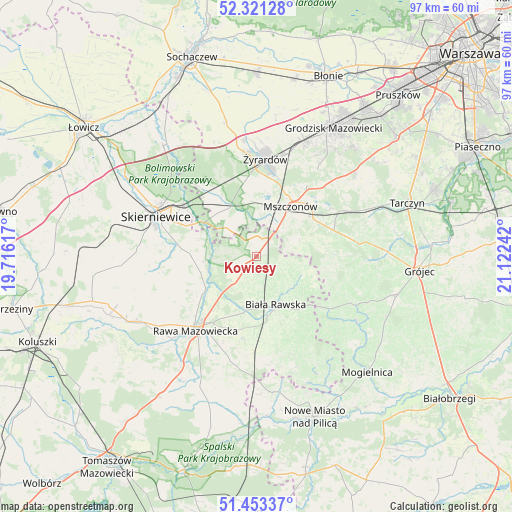
Kowiesy GPS coordinates[2]
51° 53' 21.912" North, 20° 25' 9.444" East
| Map corner | latitude | longitude |
|---|---|---|
| Upper-left | 52.32128°, | 19.71617° |
| Center: | 51.88942°, | 20.41929° |
| Lower-right: | 51.45337°, | 21.12242° |
| Map W x H: | 96.5×96.5 km | = 60×60mi |
| max Lat: | 54.83135° ⇑36.6% North |
| Kowiesy: | 51.88942° |
| min Lat: | ⇓63.4% South 49.21328° |
| min Long | Kowiesy | max Long |
| 14.20249° | 20.41929° | 24.03723° |
| W 63.9%⇐ | ⇒36.1% E |
Elevation
Elevation of Kowiesy is 155 m = 509 ft, and this is 36.4 m = 119 ft below average elevation for this country.
| Max E: |
974 m = 3196 ft | 56.4% |
| Avg. | 191.4 m = 628 ft | |
| Kowiesy | 155 m = 509 ft | |
Min E: |
-3 m = -10 ft | 43.6% |
See also: Poland elevation on elevation.city.
Geographical zone
Kowiesy is located in North temperate zone (between Tropic of Cancer and the Arctic Circle). Distance of this North polar circle is 1631.6 km =1013.8 mi to North.| Distance of | km | miles | from Kowiesy |
|---|---|---|---|
| North Pole | 4237.5 | 2633.1 | to North |
| Arctic Circle | 1631.6 | 1013.8 | to North |
| Tropic Cancer | 3163.6 | 1965.8 | to South |
| Equator | 5769.6 | 3585.1 | to South |


Nearby cities:
15 places around Kowiesy: (largest is in red/bold)
• Biała Rawska
9.8 km =6.1 mi,  158°
158°
• Cielądz
20 km =12.4 mi,  194°
194°
• Franciszków
15.9 km =9.9 mi,  337°
337°
• Jesionka
15.6 km =9.7 mi, 343°
• Kawęczyn Nowy
11.8 km =7.3 mi,  268°
268°
• Miedniewice
17 km =10.6 mi,  295°
295°
• Mrozy
14.9 km =9.3 mi,  346°
346°
• Mszczonów
11.7 km =7.3 mi,  36°
36°
• Puszcza Mariańska
11 km =6.8 mi,  334°
334°
• Radziejowice
15.9 km =9.9 mi,  33°
33°
• Rawa Mazowiecka
17.9 km =11.1 mi,  219°
219°
• Regnów
15.8 km =9.8 mi, 188°
• Sadkowice
19.4 km =12.1 mi, 160°
• Skierniewice
19.3 km =12 mi,  292°
292°
• Żyrardów
17.8 km =11.1 mi,  5°
5°
Sources, notices
• [Note1] Compared only with cities in Poland existing in our database
• [Src1] Map data: © OpenStreetMap contributors (CC-BY-SA)
• [Src2] Other city data from geonames.org with taken over terms of usage.
• [Src3] Geographical zone / Annual Mean Temperature by Robert A. Rohde @ Wikipedia
