Biała Rawska geodata
Biała Rawska (Łódź Voivodeship) is a seat of a third-order administrative division; located in Poland in Europe/Warsaw (GMT+2) time zone. With population of 3,231 people, there are 981 cities with bigger population in this country. Compared to other cities in Poland, 62.3% of cities are located further ↓South; 64.7% of cities are located further ←West and 56% of cities have higher elevation than Biała Rawska. Note1


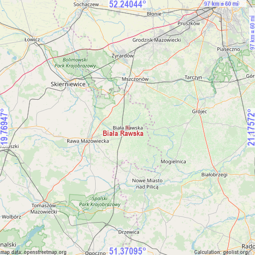
Biała Rawska GPS coordinates[2]
51° 48' 28.044" North, 20° 28' 21.324" East
| Map corner | latitude | longitude |
|---|---|---|
| Upper-left | 52.24044°, | 19.76947° |
| Center: | 51.80779°, | 20.47259° |
| Lower-right: | 51.37095°, | 21.17572° |
| Map W x H: | 96.7×96.7 km | = 60.1×60.1mi |
| max Lat: | 54.83135° ⇑37.7% North |
| Biała Rawska: | 51.80779° |
| min Lat: | ⇓62.3% South 49.21328° |
| min Long | Biała Rawska | max Long |
| 14.20249° | 20.47259° | 24.03723° |
| W 64.7%⇐ | ⇒35.3% E |
Elevation
Elevation of Biała Rawska is 156 m = 512 ft, and this is 35.4 m = 116 ft below average elevation for this country.
| Max E: |
974 m = 3196 ft | 56% |
| Avg. | 191.4 m = 628 ft | |
| Biała Rawska | 156 m = 512 ft | |
Min E: |
-3 m = -10 ft | 44% |
See also: Poland elevation on elevation.city.
Geographical zone
Biała Rawska is located in North temperate zone (between Tropic of Cancer and the Arctic Circle). Distance of this North polar circle is 1640.7 km =1019.5 mi to North.| Distance of | km | miles | from Biała Rawska |
|---|---|---|---|
| North Pole | 4246.6 | 2638.7 | to North |
| Arctic Circle | 1640.7 | 1019.5 | to North |
| Tropic Cancer | 3154.6 | 1960.2 | to South |
| Equator | 5760.5 | 3579.4 | to South |


Nearby cities:
15 places around Biała Rawska: (largest is in red/bold)
• Belsk Duży
23.2 km =14.4 mi,  85°
85°
• Błędów
15.9 km =9.9 mi,  102°
102°
• Cielądz
13.5 km =8.4 mi,  220°
220°
• Kawęczyn Nowy
17.8 km =11.1 mi,  299°
299°
• Kowiesy
9.8 km =6.1 mi,  338°
338°
• Mogielnica
21.3 km =13.2 mi,  126°
126°
• Mszczonów
18.8 km =11.7 mi,  10°
10°
• Nowe Miasto nad Pilicą
22.3 km =13.9 mi,  161°
161°
• Pniewy
22.2 km =13.8 mi,  57°
57°
• Puszcza Mariańska
20.8 km =12.9 mi, 336°
• Radziejowice
22.9 km =14.2 mi, 13°
• Rawa Mazowiecka
15.7 km =9.8 mi,  252°
252°
• Regnów
8.8 km =5.5 mi, 221°
• Sadkowice
9.6 km =6 mi, 162°
• Złota
22 km =13.7 mi,  259°
259°
Sources, notices
• [Note1] Compared only with cities in Poland existing in our database
• [Src1] Map data: © OpenStreetMap contributors (CC-BY-SA)
• [Src2] Other city data from geonames.org with taken over terms of usage.
• [Src3] Geographical zone / Annual Mean Temperature by Robert A. Rohde @ Wikipedia
