Żyrardów geodata
Żyrardów (Mazovia) is a seat of a second-order administrative division; located in Poland in Europe/Warsaw (GMT+2) time zone. With population of 41,179 people, there are 120 cities with bigger population in this country. Compared to other cities in Poland, 66.5% of cities are located further ↓South; 64.3% of cities are located further ←West and 71.6% of cities have higher elevation than Żyrardów. Note1


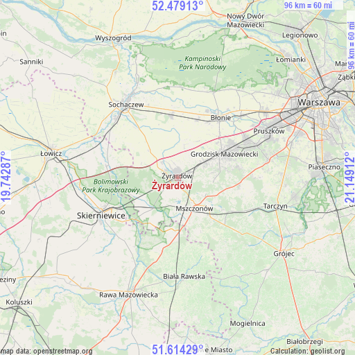
Żyrardów GPS coordinates[2]
52° 2' 55.68" North, 20° 26' 45.564" East
| Map corner | latitude | longitude |
|---|---|---|
| Upper-left | 52.47913°, | 19.74287° |
| Center: | 52.0488°, | 20.44599° |
| Lower-right: | 51.61429°, | 21.14912° |
| Map W x H: | 96.2×96.2 km | = 59.8×59.8mi |
| max Lat: | 54.83135° ⇑33.5% North |
| Żyrardów: | 52.0488° |
| min Lat: | ⇓66.5% South 49.21328° |
| min Long | Żyrardów | max Long |
| 14.20249° | 20.44599° | 24.03723° |
| W 64.3%⇐ | ⇒35.7% E |
Elevation
Elevation of Żyrardów is 118 m = 387 ft, and this is 73.4 m = 241 ft below average elevation for this country.
| Max E: |
974 m = 3196 ft | 71.6% |
| Avg. | 191.4 m = 628 ft | |
| Żyrardów | 118 m = 387 ft | |
Min E: |
-3 m = -10 ft | 28.4% |
See also: Żyrardów elevation on elevation.city.
Geographical zone
Żyrardów is located in North temperate zone (between Tropic of Cancer and the Arctic Circle). Distance of this North polar circle is 1613.9 km =1002.8 mi to North.| Distance of | km | miles | from Żyrardów |
|---|---|---|---|
| North Pole | 4219.8 | 2622.1 | to North |
| Arctic Circle | 1613.9 | 1002.8 | to North |
| Tropic Cancer | 3181.4 | 1976.8 | to South |
| Equator | 5787.3 | 3596.1 | to South |


Nearby cities:
15 places around Żyrardów: (largest is in red/bold)
• Bieniewice
16.9 km =10.5 mi,  28°
28°
• Boża Wola
16.2 km =10.1 mi,  19°
19°
• Franciszków
8.5 km =5.3 mi,  248°
248°
• Grodzisk Mazowiecki
14.2 km =8.8 mi,  64°
64°
• Guzów
10.6 km =6.6 mi,  315°
315°
• Jaktorów
7.5 km =4.7 mi, 64°
• Jesionka
6.9 km =4.3 mi, 246°
• Miedniewice
10.5 km =6.5 mi,  291°
291°
• Mrozy
6.3 km =3.9 mi,  239°
239°
• Mszczonów
9.8 km =6.1 mi,  148°
148°
• Puszcza Mariańska
10.2 km =6.3 mi,  220°
220°
• Radziejowice
8.3 km =5.2 mi,  122°
122°
• Teresin
16.8 km =10.4 mi,  353°
353°
• Wiskitki
6 km =3.7 mi, 317°
• Żabia Wola
16.9 km =10.5 mi,  96°
96°
Sources, notices
• [Note1] Compared only with cities in Poland existing in our database
• [Src1] Map data: © OpenStreetMap contributors (CC-BY-SA)
• [Src2] Other city data from geonames.org with taken over terms of usage.
• [Src3] Geographical zone / Annual Mean Temperature by Robert A. Rohde @ Wikipedia
