Puszcza Mariańska geodata
Puszcza Mariańska (Mazovia) is a seat of a third-order administrative division; located in Poland in Europe/Warsaw (GMT+2) time zone. With population of 500 people, there are 3540 cities with bigger population in this country. Compared to other cities in Poland, 65.4% of cities are located further ↓South; 63.2% of cities are located further ←West and 63.7% of cities have higher elevation than Puszcza Mariańska. Note1


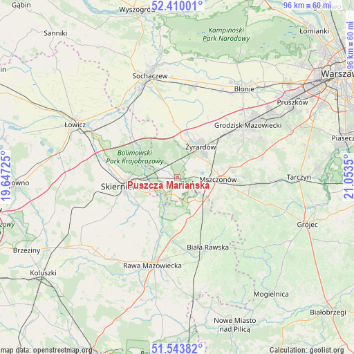
Puszcza Mariańska GPS coordinates[2]
51° 58' 44.436" North, 20° 21' 1.332" East
| Map corner | latitude | longitude |
|---|---|---|
| Upper-left | 52.41001°, | 19.64725° |
| Center: | 51.97901°, | 20.35037° |
| Lower-right: | 51.54382°, | 21.0535° |
| Map W x H: | 96.3×96.3 km | = 59.8×59.8mi |
| max Lat: | 54.83135° ⇑34.6% North |
| Puszcza Mariańska: | 51.97901° |
| min Lat: | ⇓65.4% South 49.21328° |
| min Long | Puszcza Mariań | max Long |
| 14.20249° | 20.35037° | 24.03723° |
| W 63.2%⇐ | ⇒36.8% E |
Elevation
Elevation of Puszcza Mariańska is 137 m = 449 ft, and this is 54.4 m = 178 ft below average elevation for this country.
| Max E: |
974 m = 3196 ft | 63.7% |
| Avg. | 191.4 m = 628 ft | |
| Puszcza Mariańska | 137 m = 449 ft | |
Min E: |
-3 m = -10 ft | 36.3% |
See also: Poland elevation on elevation.city.
Geographical zone
Puszcza Mariańska is located in North temperate zone (between Tropic of Cancer and the Arctic Circle). Distance of this North polar circle is 1621.6 km =1007.6 mi to North.| Distance of | km | miles | from Puszcza Mariańska |
|---|---|---|---|
| North Pole | 4227.5 | 2626.8 | to North |
| Arctic Circle | 1621.6 | 1007.6 | to North |
| Tropic Cancer | 3173.6 | 1972 | to South |
| Equator | 5779.5 | 3591.2 | to South |


Nearby cities:
15 places around Puszcza Mariańska: (largest is in red/bold)
• Bolimów
16.8 km =10.4 mi,  310°
310°
• Franciszków
4.9 km =3 mi,  343°
343°
• Guzów
15.3 km =9.5 mi,  356°
356°
• Jaktorów
17.3 km =10.7 mi,  50°
50°
• Jesionka
5 km =3.1 mi,  2°
2°
• Kawęczyn Nowy
12.5 km =7.8 mi,  214°
214°
• Kowiesy
11 km =6.8 mi,  154°
154°
• Miedniewice
10.8 km =6.7 mi,  256°
256°
• Miedniewice
12 km =7.5 mi, 344°
• Mrozy
4.7 km =2.9 mi,  14°
14°
• Mszczonów
11.7 km =7.3 mi,  92°
92°
• Radziejowice
13.9 km =8.6 mi,  76°
76°
• Skierniewice
13.4 km =8.3 mi, 258°
• Wiskitki
12.4 km =7.7 mi, 11°
• Żyrardów
10.2 km =6.3 mi,  40°
40°
Sources, notices
• [Note1] Compared only with cities in Poland existing in our database
• [Src1] Map data: © OpenStreetMap contributors (CC-BY-SA)
• [Src2] Other city data from geonames.org with taken over terms of usage.
• [Src3] Geographical zone / Annual Mean Temperature by Robert A. Rohde @ Wikipedia
