Lipnica geodata
Lipnica (Subcarpathian) is a populated place; located in Poland in Europe/Warsaw (GMT+2) time zone. With population of 1,300 people, there are 2055 cities with bigger population in this country. Compared to other cities in Poland, 72.3% of cities are located further ↑North; 83.3% of cities are located further ←West and 67.4% of cities have lower elevation than Lipnica. Note1


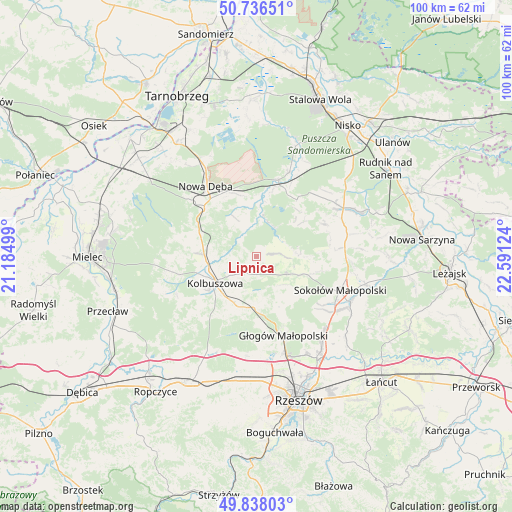
Lipnica GPS coordinates[2]
50° 17' 21.804" North, 21° 53' 17.196" East
| Map corner | latitude | longitude |
|---|---|---|
| Upper-left | 50.73651°, | 21.18499° |
| Center: | 50.28939°, | 21.88811° |
| Lower-right: | 49.83803°, | 22.59124° |
| Map W x H: | 99.9×99.9 km | = 62.1×62.1mi |
| max Lat: | 54.83135° ⇑72.3% North |
| Lipnica: | 50.28939° |
| min Lat: | ⇓27.7% South 49.21328° |
| min Long | Lipnica | max Long |
| 14.20249° | 21.88811° | 24.03723° |
| W 83.3%⇐ | ⇒16.7% E |
Elevation
Elevation of Lipnica is 221 m = 725 ft, and this is 29.6 m = 97 ft above average elevation for this country.
| Max E: |
974 m = 3196 ft | 32.6% |
| Lipnica | 221 m 725 ft | |
| Avg. | 191.4 m = 628 ft | |
Min E: |
-3 m = -10 ft | 67.4% |
See also: Poland elevation on elevation.city.
Geographical zone
Lipnica is located in North temperate zone (between Tropic of Cancer and the Arctic Circle). Distance of this North polar circle is 1809.5 km =1124.4 mi to North.| Distance of | km | miles | from Lipnica |
|---|---|---|---|
| North Pole | 4415.4 | 2743.6 | to North |
| Arctic Circle | 1809.5 | 1124.4 | to North |
| Tropic Cancer | 2985.7 | 1855.2 | to South |
| Equator | 5591.7 | 3474.5 | to South |


Nearby cities:
15 places around Lipnica: (largest is in red/bold)
• Bojanów
15.8 km =9.8 mi,  16°
16°
• Cholewiana Góra
14.9 km =9.3 mi,  63°
63°
• Cmolas
10.2 km =6.3 mi,  273°
273°
• Dzikowiec
3.7 km =2.3 mi,  239°
239°
• Gwoździec
12.1 km =7.5 mi,  37°
37°
• Głogów Małopolski
16.3 km =10.1 mi,  160°
160°
• Kolbuszowa
9.4 km =5.8 mi, 237°
• Majdan Królewski
14.2 km =8.8 mi,  314°
314°
• Mechowiec
5.5 km =3.4 mi, 266°
• Ostrowy Baranowskie
17.2 km =10.7 mi,  288°
288°
• Ostrowy Tuszowskie
17.1 km =10.6 mi,  280°
280°
• Raniżów
6.8 km =4.2 mi,  119°
119°
• Sokołów Małopolski
17.8 km =11.1 mi,  112°
112°
• Trześń
16.9 km =10.5 mi, 244°
• Wysoka Głogowska
17.2 km =10.7 mi,  146°
146°
Sources, notices
• [Note1] Compared only with cities in Poland existing in our database
• [Src1] Map data: © OpenStreetMap contributors (CC-BY-SA)
• [Src2] Other city data from geonames.org with taken over terms of usage.
• [Src3] Geographical zone / Annual Mean Temperature by Robert A. Rohde @ Wikipedia
