Raniżów geodata
Raniżów (Subcarpathian) is a seat of a third-order administrative division; located in Poland in Europe/Warsaw (GMT+2) time zone. With population of 2,200 people, there are 1362 cities with bigger population in this country. Compared to other cities in Poland, 73% of cities are located further ↑North; 84.6% of cities are located further ←West and 60.3% of cities have lower elevation than Raniżów. Note1


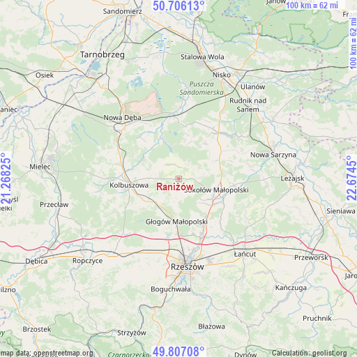
Raniżów GPS coordinates[2]
50° 15' 31.428" North, 21° 58' 16.932" East
| Map corner | latitude | longitude |
|---|---|---|
| Upper-left | 50.70613°, | 21.26825° |
| Center: | 50.25873°, | 21.97137° |
| Lower-right: | 49.80708°, | 22.6745° |
| Map W x H: | 100×100 km | = 62.1×62.1mi |
| max Lat: | 54.83135° ⇑73% North |
| Raniżów: | 50.25873° |
| min Lat: | ⇓27% South 49.21328° |
| min Long | Raniżów | max Long |
| 14.20249° | 21.97137° | 24.03723° |
| W 84.6%⇐ | ⇒15.4% E |
Elevation
Elevation of Raniżów is 201 m = 659 ft, and this is 9.6 m = 31 ft above average elevation for this country.
| Max E: |
974 m = 3196 ft | 39.7% |
| Raniżów | 201 m 659 ft | |
| Avg. | 191.4 m = 628 ft | |
Min E: |
-3 m = -10 ft | 60.3% |
See also: Poland elevation on elevation.city.
Geographical zone
Raniżów is located in North temperate zone (between Tropic of Cancer and the Arctic Circle). Distance of this North polar circle is 1812.9 km =1126.5 mi to North.| Distance of | km | miles | from Raniżów |
|---|---|---|---|
| North Pole | 4418.8 | 2745.7 | to North |
| Arctic Circle | 1812.9 | 1126.5 | to North |
| Tropic Cancer | 2982.3 | 1853.1 | to South |
| Equator | 5588.2 | 3472.3 | to South |


Nearby cities:
15 places around Raniżów: (largest is in red/bold)
• Cholewiana Góra
12.5 km =7.8 mi,  36°
36°
• Cmolas
16.6 km =10.3 mi,  284°
284°
• Dzikowiec
9.2 km =5.7 mi, 279°
• Gwoździec
13.1 km =8.1 mi,  6°
6°
• Górno
12.6 km =7.8 mi,  77°
77°
• Głogów Małopolski
12 km =7.5 mi,  182°
182°
• Jeżowe
17 km =10.6 mi, 40°
• Kamień
14.8 km =9.2 mi,  51°
51°
• Kolbuszowa
14 km =8.7 mi,  263°
263°
• Lipnica
6.8 km =4.2 mi,  299°
299°
• Mechowiec
11.8 km =7.3 mi,  285°
285°
• Rudna Mała
17.8 km =11.1 mi, 182°
• Sokołów Małopolski
11 km =6.8 mi,  107°
107°
• Wysoka Głogowska
11.5 km =7.1 mi,  162°
162°
• Wólka Niedźwiedzka
15.5 km =9.6 mi,  96°
96°
Sources, notices
• [Note1] Compared only with cities in Poland existing in our database
• [Src1] Map data: © OpenStreetMap contributors (CC-BY-SA)
• [Src2] Other city data from geonames.org with taken over terms of usage.
• [Src3] Geographical zone / Annual Mean Temperature by Robert A. Rohde @ Wikipedia
