Trzciana geodata
Trzciana (Subcarpathian) is a populated place; located in Poland in Europe/Warsaw (GMT+2) time zone. With population of 2,300 people, there are 1321 cities with bigger population in this country. Compared to other cities in Poland, 79.1% of cities are located further ↑North; 82.6% of cities are located further ←West and 70.6% of cities have lower elevation than Trzciana. Note1


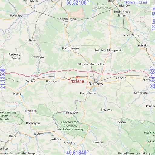
Trzciana GPS coordinates[2]
50° 4' 18.84" North, 21° 50' 18.6" East
| Map corner | latitude | longitude |
|---|---|---|
| Upper-left | 50.52106°, | 21.13538° |
| Center: | 50.0719°, | 21.8385° |
| Lower-right: | 49.61849°, | 22.54163° |
| Map W x H: | 100.4×100.4 km | = 62.4×62.4mi |
| max Lat: | 54.83135° ⇑79.1% North |
| Trzciana: | 50.0719° |
| min Lat: | ⇓20.9% South 49.21328° |
| min Long | Trzciana | max Long |
| 14.20249° | 21.8385° | 24.03723° |
| W 82.6%⇐ | ⇒17.4% E |
Elevation
Elevation of Trzciana is 231 m = 758 ft, and this is 39.6 m = 130 ft above average elevation for this country.
| Max E: |
974 m = 3196 ft | 29.4% |
| Trzciana | 231 m 758 ft | |
| Avg. | 191.4 m = 628 ft | |
Min E: |
-3 m = -10 ft | 70.6% |
See also: Poland elevation on elevation.city.
Geographical zone
Trzciana is located in North temperate zone (between Tropic of Cancer and the Arctic Circle). Distance of this North polar circle is 1833.7 km =1139.4 mi to North.| Distance of | km | miles | from Trzciana |
|---|---|---|---|
| North Pole | 4439.6 | 2758.6 | to North |
| Arctic Circle | 1833.7 | 1139.4 | to North |
| Tropic Cancer | 2961.6 | 1840.3 | to South |
| Equator | 5567.5 | 3459.5 | to South |


Nearby cities:
15 places around Trzciana: (largest is in red/bold)
• Boguchwała
12.3 km =7.6 mi,  141°
141°
• Głogów Małopolski
12.5 km =7.8 mi,  45°
45°
• Iwierzyce
7.7 km =4.8 mi,  232°
232°
• Kielanówka
8.2 km =5.1 mi,  128°
128°
• Krzywa
8.1 km =5 mi,  293°
293°
• Lutoryż
12.8 km =8 mi,  155°
155°
• Niechobrz
9 km =5.6 mi, 161°
• Przybyszówka
6.8 km =4.2 mi,  113°
113°
• Rudna Mała
9.2 km =5.7 mi,  70°
70°
• Rudna Wielka
8 km =5 mi,  77°
77°
• Rzeszów
12 km =7.5 mi, 106°
• Sędziszów Małopolski
9.8 km =6.1 mi,  269°
269°
• Wiśniowa
10.2 km =6.3 mi,  216°
216°
• Zgłobień
6.7 km =4.2 mi,  169°
169°
• Świlcza
4.2 km =2.6 mi,  90°
90°
Sources, notices
• [Note1] Compared only with cities in Poland existing in our database
• [Src1] Map data: © OpenStreetMap contributors (CC-BY-SA)
• [Src2] Other city data from geonames.org with taken over terms of usage.
• [Src3] Geographical zone / Annual Mean Temperature by Robert A. Rohde @ Wikipedia
