Jaśliska geodata
Jaśliska (Subcarpathian) is a seat of a third-order administrative division; located in Poland in Europe/Warsaw (GMT+2) time zone. With population of 480 people, there are 3548 cities with bigger population in this country. Compared to other cities in Poland, 99.2% of cities are located further ↑North; 82.3% of cities are located further ←West and 95.6% of cities have lower elevation than Jaśliska. Note1


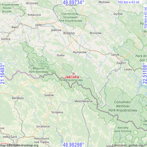
Jaśliska GPS coordinates[2]
49° 26' 32.244" North, 21° 48' 28.62" East
| Map corner | latitude | longitude |
|---|---|---|
| Upper-left | 49.89734°, | 21.10483° |
| Center: | 49.44229°, | 21.80795° |
| Lower-right: | 48.98298°, | 22.51108° |
| Map W x H: | 101.7×101.7 km | = 63.2×63.2mi |
| max Lat: | 54.83135° ⇑99.2% North |
| Jaśliska: | 49.44229° |
| min Lat: | ⇓0.8% South 49.21328° |
| min Long | Jaśliska | max Long |
| 14.20249° | 21.80795° | 24.03723° |
| W 82.3%⇐ | ⇒17.7% E |
Elevation
Elevation of Jaśliska is 431 m = 1414 ft, and this is 239.6 m = 786 ft above average elevation for this country.
| Max E: |
974 m = 3196 ft | 4.4% |
| Jaśliska | 431 m 1414 ft | |
| Avg. | 191.4 m = 628 ft | |
Min E: |
-3 m = -10 ft | 95.6% |
See also: Poland elevation on elevation.city.
Geographical zone
Jaśliska is located in North temperate zone (between Tropic of Cancer and the Arctic Circle). Distance of this North polar circle is 1903.7 km =1182.9 mi to North.| Distance of | km | miles | from Jaśliska |
|---|---|---|---|
| North Pole | 4509.6 | 2802.1 | to North |
| Arctic Circle | 1903.7 | 1182.9 | to North |
| Tropic Cancer | 2891.5 | 1796.7 | to South |
| Equator | 5497.5 | 3416 | to South |


Nearby cities:
15 places around Jaśliska: (largest is in red/bold)
• Besko
19.2 km =11.9 mi,  32°
32°
• Bukowsko
18.9 km =11.7 mi,  77°
77°
• Dukla
15.5 km =9.6 mi,  324°
324°
• Długie
22.8 km =14.2 mi,  48°
48°
• Głębokie
13.7 km =8.5 mi, 32°
• Iwonicz-Zdrój
13.5 km =8.4 mi,  354°
354°
• Komańcza
21.6 km =13.4 mi,  121°
121°
• Krempna
23.5 km =14.6 mi,  289°
289°
• Miejsce Piastowe
21.4 km =13.3 mi,  356°
356°
• Nowosielce-Gniewosz
23.5 km =14.6 mi, 53°
• Pielnia
20.6 km =12.8 mi,  59°
59°
• Rymanów
15.5 km =9.6 mi,  16°
16°
• Rzepedź
23.4 km =14.5 mi,  110°
110°
• Sieniawa
16.2 km =10.1 mi, 32°
• Zarszyn
21.4 km =13.3 mi,  43°
43°
Sources, notices
• [Note1] Compared only with cities in Poland existing in our database
• [Src1] Map data: © OpenStreetMap contributors (CC-BY-SA)
• [Src2] Other city data from geonames.org with taken over terms of usage.
• [Src3] Geographical zone / Annual Mean Temperature by Robert A. Rohde @ Wikipedia
