Miejsce Piastowe geodata
Miejsce Piastowe (Subcarpathian) is a seat of a third-order administrative division; located in Poland in Europe/Warsaw (GMT+2) time zone. With population of 2,000 people, there are 1469 cities with bigger population in this country. Compared to other cities in Poland, 96% of cities are located further ↑North; 82.1% of cities are located further ←West and 87.7% of cities have lower elevation than Miejsce Piastowe. Note1
Administrative division(s):
- Level 1: Subcarpathian
- Level 2: Powiat krośnieński
- Level 3: Miejsce Piastowe


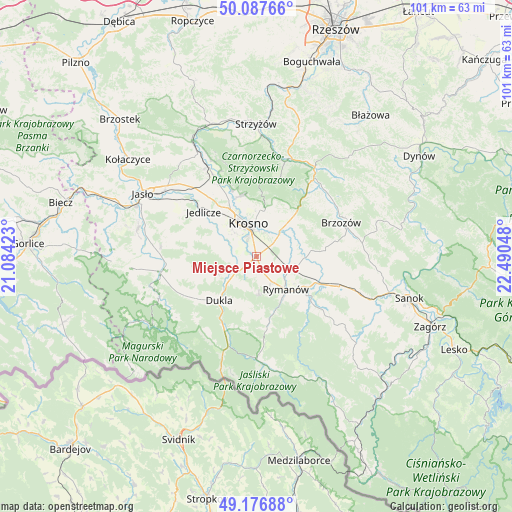
Miejsce Piastowe GPS coordinates[2]
49° 38' 3.84" North, 21° 47' 14.46" East
| Map corner | latitude | longitude |
|---|---|---|
| Upper-left | 50.08766°, | 21.08423° |
| Center: | 49.6344°, | 21.78735° |
| Lower-right: | 49.17688°, | 22.49048° |
| Map W x H: | 101.3×101.3 km | = 62.9×62.9mi |
| max Lat: | 54.83135° ⇑96% North |
| Miejsce Piastowe: | 49.6344° |
| min Lat: | ⇓4% South 49.21328° |
| min Long | Miejsce Piastow | max Long |
| 14.20249° | 21.78735° | 24.03723° |
| W 82.1%⇐ | ⇒17.9% E |
Elevation
Elevation of Miejsce Piastowe is 306 m = 1004 ft, and this is 114.6 m = 376 ft above average elevation for this country.
| Max E: |
974 m = 3196 ft | 12.3% |
| Miejsce Piastowe | 306 m 1004 ft | |
| Avg. | 191.4 m = 628 ft | |
Min E: |
-3 m = -10 ft | 87.7% |
See also: Poland elevation on elevation.city.
Geographical zone
Miejsce Piastowe is located in North temperate zone (between Tropic of Cancer and the Arctic Circle). Distance of this North polar circle is 1882.3 km =1169.6 mi to North.| Distance of | km | miles | from Miejsce Piastowe |
|---|---|---|---|
| North Pole | 4488.2 | 2788.8 | to North |
| Arctic Circle | 1882.3 | 1169.6 | to North |
| Tropic Cancer | 2912.9 | 1810 | to South |
| Equator | 5518.8 | 3429.2 | to South |


Nearby cities:
15 places around Miejsce Piastowe: (largest is in red/bold)
• Besko
13 km =8.1 mi,  113°
113°
• Chorkówka
8.4 km =5.2 mi,  279°
279°
• Dukla
11.5 km =7.1 mi,  220°
220°
• Głębokie
13.2 km =8.2 mi,  138°
138°
• Haczów
8.5 km =5.3 mi,  69°
69°
• Iwonicz-Zdrój
7.9 km =4.9 mi,  178°
178°
• Jabłonica Polska
10.7 km =6.6 mi,  48°
48°
• Jedlicze
13.6 km =8.5 mi,  312°
312°
• Korczyna
9.2 km =5.7 mi,  9°
9°
• Krosno
6.2 km =3.9 mi,  348°
348°
• Krościenko Wyżne
5.8 km =3.6 mi,  30°
30°
• Malinówka
12.3 km =7.6 mi,  55°
55°
• Odrzykoń
12.3 km =7.6 mi,  344°
344°
• Rymanów
8.7 km =5.4 mi, 137°
• Sieniawa
12.7 km =7.9 mi,  127°
127°
Sources, notices
• [Note1] Compared only with cities in Poland existing in our database
• [Src1] Map data: © OpenStreetMap contributors (CC-BY-SA)
• [Src2] Other city data from geonames.org with taken over terms of usage.
• [Src3] Geographical zone / Annual Mean Temperature by Robert A. Rohde @ Wikipedia
