Krosno geodata
Krosno (Subcarpathian) is a seat of a third-order administrative division; located in Poland in Europe/Warsaw (GMT+2) time zone. With population of 47,784 people, there are 108 cities with bigger population in this country. Compared to other cities in Poland, 94.8% of cities are located further ↑North; 82% of cities are located further ←West and 82.5% of cities have lower elevation than Krosno. Note1


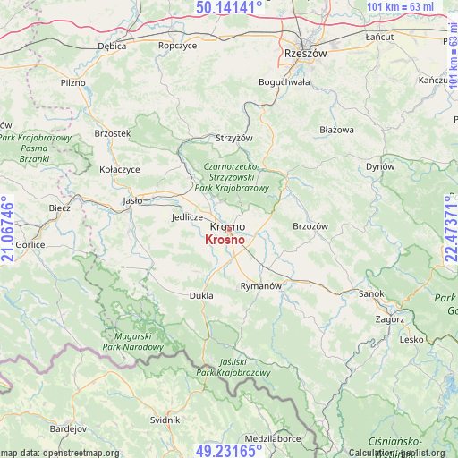
Krosno GPS coordinates[2]
49° 41' 19.176" North, 21° 46' 14.088" East
| Map corner | latitude | longitude |
|---|---|---|
| Upper-left | 50.14141°, | 21.06746° |
| Center: | 49.68866°, | 21.77058° |
| Lower-right: | 49.23165°, | 22.47371° |
| Map W x H: | 101.2×101.2 km | = 62.9×62.9mi |
| max Lat: | 54.83135° ⇑94.8% North |
| Krosno: | 49.68866° |
| min Lat: | ⇓5.2% South 49.21328° |
| min Long | Krosno | max Long |
| 14.20249° | 21.77058° | 24.03723° |
| W 82%⇐ | ⇒18% E |
Elevation
Elevation of Krosno is 278 m = 912 ft, and this is 86.6 m = 284 ft above average elevation for this country.
| Max E: |
974 m = 3196 ft | 17.5% |
| Krosno | 278 m 912 ft | |
| Avg. | 191.4 m = 628 ft | |
Min E: |
-3 m = -10 ft | 82.5% |
See also: Krosno elevation on elevation.city.
Geographical zone
Krosno is located in North temperate zone (between Tropic of Cancer and the Arctic Circle). Distance of this North polar circle is 1876.3 km =1165.9 mi to North.| Distance of | km | miles | from Krosno |
|---|---|---|---|
| North Pole | 4482.2 | 2785.1 | to North |
| Arctic Circle | 1876.3 | 1165.9 | to North |
| Tropic Cancer | 2918.9 | 1813.7 | to South |
| Equator | 5524.9 | 3433 | to South |


Nearby cities:
15 places around Krosno: (largest is in red/bold)
• Chorkówka
8.5 km =5.3 mi,  236°
236°
• Haczów
9.6 km =6 mi,  108°
108°
• Iwonicz-Zdrój
14 km =8.7 mi,  174°
174°
• Jabłonica Polska
9.3 km =5.8 mi,  83°
83°
• Jasienica Rosielna
14.1 km =8.8 mi,  60°
60°
• Jedlicze
9.3 km =5.8 mi,  290°
290°
• Korczyna
4.1 km =2.5 mi,  43°
43°
• Krasna
11.4 km =7.1 mi,  31°
31°
• Krościenko Wyżne
4.3 km =2.7 mi,  103°
103°
• Malinówka
11.3 km =7 mi,  85°
85°
• Miejsce Piastowe
6.2 km =3.9 mi, 168°
• Odrzykoń
6.2 km =3.9 mi,  339°
339°
• Orzechówka
13.4 km =8.3 mi,  69°
69°
• Wojaszówka
12.2 km =7.6 mi,  324°
324°
• Zmiennica
14.1 km =8.8 mi, 95°
Sources, notices
• [Note1] Compared only with cities in Poland existing in our database
• [Src1] Map data: © OpenStreetMap contributors (CC-BY-SA)
• [Src2] Other city data from geonames.org with taken over terms of usage.
• [Src3] Geographical zone / Annual Mean Temperature by Robert A. Rohde @ Wikipedia
