Gościeradów geodata
Gościeradów (Lublin) is a seat of a third-order administrative division; located in Poland in Europe/Warsaw (GMT+2) time zone. With population of 960 people, there are 2570 cities with bigger population in this country. Compared to other cities in Poland, 58.6% of cities are located further ↑North; 85% of cities are located further ←West and 50.8% of cities have lower elevation than Gościeradów. Note1


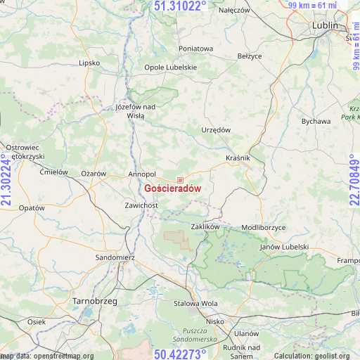
Gościeradów GPS coordinates[2]
50° 52' 6.924" North, 22° 0' 19.296" East
| Map corner | latitude | longitude |
|---|---|---|
| Upper-left | 51.31022°, | 21.30224° |
| Center: | 50.86859°, | 22.00536° |
| Lower-right: | 50.42273°, | 22.70849° |
| Map W x H: | 98.7×98.7 km | = 61.3×61.3mi |
| max Lat: | 54.83135° ⇑58.6% North |
| Gościeradów: | 50.86859° |
| min Lat: | ⇓41.4% South 49.21328° |
| min Long | Gościeradów | max Long |
| 14.20249° | 22.00536° | 24.03723° |
| W 85%⇐ | ⇒15% E |
Elevation
Elevation of Gościeradów is 174 m = 571 ft, and this is 17.4 m = 57 ft below average elevation for this country.
| Max E: |
974 m = 3196 ft | 49.2% |
| Avg. | 191.4 m = 628 ft | |
| Gościeradów | 174 m = 571 ft | |
Min E: |
-3 m = -10 ft | 50.8% |
See also: Poland elevation on elevation.city.
Geographical zone
Gościeradów is located in North temperate zone (between Tropic of Cancer and the Arctic Circle). Distance of this North polar circle is 1745.1 km =1084.4 mi to North.| Distance of | km | miles | from Gościeradów |
|---|---|---|---|
| North Pole | 4351 | 2703.6 | to North |
| Arctic Circle | 1745.1 | 1084.4 | to North |
| Tropic Cancer | 3050.1 | 1895.2 | to South |
| Equator | 5656.1 | 3514.5 | to South |


Nearby cities:
15 places around Gościeradów: (largest is in red/bold)
• Annopol
10.6 km =6.6 mi,  280°
280°
• Chwałowice
14.1 km =8.8 mi,  216°
216°
• Dzierzkowice
11 km =6.8 mi,  22°
22°
• Kraśnik
16.7 km =10.4 mi,  68°
68°
• Księżomierz
4.6 km =2.9 mi,  346°
346°
• Ludmiłówka
7.3 km =4.5 mi, 15°
• Potok Wielki
17.1 km =10.6 mi,  120°
120°
• Rzeczyca Ziemiańska
12.9 km =8 mi,  102°
102°
• Trzydnik Duży
9.3 km =5.8 mi, 103°
• Urzędów
16.9 km =10.5 mi,  34°
34°
• Wierzbica
18.8 km =11.7 mi, 22°
• Zaklików
14.1 km =8.8 mi,  151°
151°
• Zawichost
12.6 km =7.8 mi,  237°
237°
• Zdziechowice Drugie
11.9 km =7.4 mi,  141°
141°
• Zdziechowice Pierwsze
11 km =6.8 mi, 139°
Sources, notices
• [Note1] Compared only with cities in Poland existing in our database
• [Src1] Map data: © OpenStreetMap contributors (CC-BY-SA)
• [Src2] Other city data from geonames.org with taken over terms of usage.
• [Src3] Geographical zone / Annual Mean Temperature by Robert A. Rohde @ Wikipedia
