Kraśnik geodata
Kraśnik (Lublin) is a seat of a second-order administrative division; located in Poland in Europe/Warsaw (GMT+2) time zone. With population of 35,834 people, there are 146 cities with bigger population in this country. Compared to other cities in Poland, 57.1% of cities are located further ↑North; 87.7% of cities are located further ←West and 59.4% of cities have lower elevation than Kraśnik. Note1


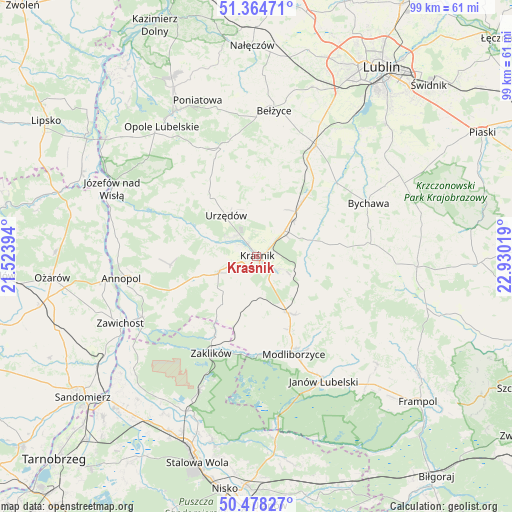
Kraśnik GPS coordinates[2]
50° 55' 24.96" North, 22° 13' 37.416" East
| Map corner | latitude | longitude |
|---|---|---|
| Upper-left | 51.36471°, | 21.52394° |
| Center: | 50.9236°, | 22.22706° |
| Lower-right: | 50.47827°, | 22.93019° |
| Map W x H: | 98.6×98.6 km | = 61.3×61.3mi |
| max Lat: | 54.83135° ⇑57.1% North |
| Kraśnik: | 50.9236° |
| min Lat: | ⇓42.9% South 49.21328° |
| min Long | Kraśnik | max Long |
| 14.20249° | 22.22706° | 24.03723° |
| W 87.7%⇐ | ⇒12.3% E |
Elevation
Elevation of Kraśnik is 199 m = 653 ft, and this is 7.6 m = 25 ft above average elevation for this country.
| Max E: |
974 m = 3196 ft | 40.6% |
| Kraśnik | 199 m 653 ft | |
| Avg. | 191.4 m = 628 ft | |
Min E: |
-3 m = -10 ft | 59.4% |
See also: Poland elevation on elevation.city.
Geographical zone
Kraśnik is located in North temperate zone (between Tropic of Cancer and the Arctic Circle). Distance of this North polar circle is 1739 km =1080.6 mi to North.| Distance of | km | miles | from Kraśnik |
|---|---|---|---|
| North Pole | 4344.9 | 2699.8 | to North |
| Arctic Circle | 1739 | 1080.6 | to North |
| Tropic Cancer | 3056.3 | 1899.1 | to South |
| Equator | 5662.2 | 3518.3 | to South |


Nearby cities:
15 places around Kraśnik: (largest is in red/bold)
• Bystrzyca
14.7 km =9.1 mi,  60°
60°
• Dzierzkowice
12 km =7.5 mi,  289°
289°
• Gościeradów
16.7 km =10.4 mi,  248°
248°
• Księżomierz
16.7 km =10.4 mi,  264°
264°
• Ludmiłówka
13.7 km =8.5 mi,  273°
273°
• Potok Wielki
14.7 km =9.1 mi,  182°
182°
• Rudnik Pierwszy
15.5 km =9.6 mi,  74°
74°
• Rzeczyca Ziemiańska
9.4 km =5.8 mi,  198°
198°
• Sułów
9.6 km =6 mi,  101°
101°
• Szastarka
10 km =6.2 mi,  139°
139°
• Trzydnik Duży
10.6 km =6.6 mi,  218°
218°
• Urzędów
9.7 km =6 mi,  322°
322°
• Wierzbica
14 km =8.7 mi, 323°
• Wilkołaz
13.3 km =8.3 mi,  40°
40°
• Zakrzówek
11.2 km =7 mi, 74°
Sources, notices
• [Note1] Compared only with cities in Poland existing in our database
• [Src1] Map data: © OpenStreetMap contributors (CC-BY-SA)
• [Src2] Other city data from geonames.org with taken over terms of usage.
• [Src3] Geographical zone / Annual Mean Temperature by Robert A. Rohde @ Wikipedia
