Annopol geodata
Annopol (Lublin) is a seat of a third-order administrative division; located in Poland in Europe/Warsaw (GMT+2) time zone. With population of 2,654 people, there are 1187 cities with bigger population in this country. Compared to other cities in Poland, 58.2% of cities are located further ↑North; 82.9% of cities are located further ←West and 53.8% of cities have lower elevation than Annopol. Note1


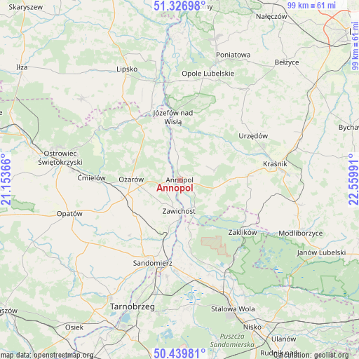
Annopol GPS coordinates[2]
50° 53' 7.836" North, 21° 51' 24.408" East
| Map corner | latitude | longitude |
|---|---|---|
| Upper-left | 51.32698°, | 21.15366° |
| Center: | 50.88551°, | 21.85678° |
| Lower-right: | 50.43981°, | 22.55991° |
| Map W x H: | 98.6×98.6 km | = 61.3×61.3mi |
| max Lat: | 54.83135° ⇑58.2% North |
| Annopol: | 50.88551° |
| min Lat: | ⇓41.8% South 49.21328° |
| min Long | Annopol | max Long |
| 14.20249° | 21.85678° | 24.03723° |
| W 82.9%⇐ | ⇒17.1% E |
Elevation
Elevation of Annopol is 182 m = 597 ft, and this is 9.4 m = 31 ft below average elevation for this country.
| Max E: |
974 m = 3196 ft | 46.2% |
| Avg. | 191.4 m = 628 ft | |
| Annopol | 182 m = 597 ft | |
Min E: |
-3 m = -10 ft | 53.8% |
See also: Poland elevation on elevation.city.
Geographical zone
Annopol is located in North temperate zone (between Tropic of Cancer and the Arctic Circle). Distance of this North polar circle is 1743.2 km =1083.2 mi to North.| Distance of | km | miles | from Annopol |
|---|---|---|---|
| North Pole | 4349.1 | 2702.4 | to North |
| Arctic Circle | 1743.2 | 1083.2 | to North |
| Tropic Cancer | 3052 | 1896.4 | to South |
| Equator | 5657.9 | 3515.7 | to South |


Nearby cities:
15 places around Annopol: (largest is in red/bold)
• Chwałowice
13.4 km =8.3 mi,  170°
170°
• Dwikozy
17.3 km =10.7 mi,  196°
196°
• Dzierzkowice
16.9 km =10.5 mi,  60°
60°
• Gościeradów
10.6 km =6.6 mi,  100°
100°
• Józefów nad Wisłą
17.5 km =10.9 mi,  353°
353°
• Księżomierz
9.7 km =6 mi,  74°
74°
• Ludmiłówka
13.4 km =8.3 mi, 67°
• Ożarów
13.3 km =8.3 mi,  271°
271°
• Sobótka
16.1 km =10 mi,  231°
231°
• Tarłów
16.3 km =10.1 mi,  322°
322°
• Trzydnik Duży
19.8 km =12.3 mi, 101°
• Wilczyce
20.8 km =12.9 mi,  222°
222°
• Wojciechowice
19.4 km =12.1 mi,  255°
255°
• Zawichost
8.7 km =5.4 mi,  181°
181°
• Zdziechowice Pierwsze
20.3 km =12.6 mi,  120°
120°
Sources, notices
• [Note1] Compared only with cities in Poland existing in our database
• [Src1] Map data: © OpenStreetMap contributors (CC-BY-SA)
• [Src2] Other city data from geonames.org with taken over terms of usage.
• [Src3] Geographical zone / Annual Mean Temperature by Robert A. Rohde @ Wikipedia
