Zawichost geodata
Zawichost (Świętokrzyskie) is a seat of a third-order administrative division; located in Poland in Europe/Warsaw (GMT+2) time zone. With population of 1,853 people, there are 1581 cities with bigger population in this country. Compared to other cities in Poland, 59.9% of cities are located further ↑North; 82.8% of cities are located further ←West and 56.4% of cities have higher elevation than Zawichost. Note1


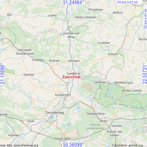
Zawichost GPS coordinates[2]
50° 48' 26.748" North, 21° 51' 14.688" East
| Map corner | latitude | longitude |
|---|---|---|
| Upper-left | 51.24964°, | 21.15096° |
| Center: | 50.80743°, | 21.85408° |
| Lower-right: | 50.36099°, | 22.55721° |
| Map W x H: | 98.8×98.8 km | = 61.4×61.4mi |
| max Lat: | 54.83135° ⇑59.9% North |
| Zawichost: | 50.80743° |
| min Lat: | ⇓40.1% South 49.21328° |
| min Long | Zawichost | max Long |
| 14.20249° | 21.85408° | 24.03723° |
| W 82.8%⇐ | ⇒17.2% E |
Elevation
Elevation of Zawichost is 155 m = 509 ft, and this is 36.4 m = 119 ft below average elevation for this country.
| Max E: |
974 m = 3196 ft | 56.4% |
| Avg. | 191.4 m = 628 ft | |
| Zawichost | 155 m = 509 ft | |
Min E: |
-3 m = -10 ft | 43.6% |
See also: Poland elevation on elevation.city.
Geographical zone
Zawichost is located in North temperate zone (between Tropic of Cancer and the Arctic Circle). Distance of this North polar circle is 1751.9 km =1088.6 mi to North.| Distance of | km | miles | from Zawichost |
|---|---|---|---|
| North Pole | 4357.8 | 2707.8 | to North |
| Arctic Circle | 1751.9 | 1088.6 | to North |
| Tropic Cancer | 3043.3 | 1891 | to South |
| Equator | 5649.3 | 3510.3 | to South |


Nearby cities:
15 places around Zawichost: (largest is in red/bold)
• Annopol
8.7 km =5.4 mi,  1°
1°
• Chwałowice
5.1 km =3.2 mi,  153°
153°
• Dwikozy
9.2 km =5.7 mi,  210°
210°
• Gorzyce
15.6 km =9.7 mi,  183°
183°
• Gościeradów
12.6 km =7.8 mi,  57°
57°
• Księżomierz
14.7 km =9.1 mi,  40°
40°
• Ożarów
15.9 km =9.9 mi,  304°
304°
• Radomyśl
15.4 km =9.6 mi,  155°
155°
• Sandomierz
15.7 km =9.8 mi, 208°
• Sobótka
12.6 km =7.8 mi,  264°
264°
• Wilczyce
15.4 km =9.6 mi,  244°
244°
• Zaleszany
17.9 km =11.1 mi,  171°
171°
• Zdziechowice Drugie
18.2 km =11.3 mi,  97°
97°
• Zdziechowice Pierwsze
17.8 km =11.1 mi, 95°
• Żabno
16.7 km =10.4 mi, 151°
Sources, notices
• [Note1] Compared only with cities in Poland existing in our database
• [Src1] Map data: © OpenStreetMap contributors (CC-BY-SA)
• [Src2] Other city data from geonames.org with taken over terms of usage.
• [Src3] Geographical zone / Annual Mean Temperature by Robert A. Rohde @ Wikipedia
