Dydnia geodata
Dydnia (Subcarpathian) is a populated place; located in Poland in Europe/Warsaw (GMT+2) time zone. With population of 1,600 people, there are 1751 cities with bigger population in this country. Compared to other cities in Poland, 94.9% of cities are located further ↑North; 87% of cities are located further ←West and 82.3% of cities have lower elevation than Dydnia. Note1


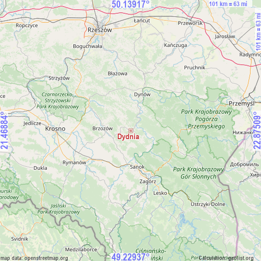
Dydnia GPS coordinates[2]
49° 41' 11.04" North, 22° 10' 19.056" East
| Map corner | latitude | longitude |
|---|---|---|
| Upper-left | 50.13917°, | 21.46884° |
| Center: | 49.6864°, | 22.17196° |
| Lower-right: | 49.22937°, | 22.87509° |
| Map W x H: | 101.2×101.2 km | = 62.9×62.9mi |
| max Lat: | 54.83135° ⇑94.9% North |
| Dydnia: | 49.6864° |
| min Lat: | ⇓5.1% South 49.21328° |
| min Long | Dydnia | max Long |
| 14.20249° | 22.17196° | 24.03723° |
| W 87%⇐ | ⇒13% E |
Elevation
Elevation of Dydnia is 277 m = 909 ft, and this is 85.6 m = 281 ft above average elevation for this country.
| Max E: |
974 m = 3196 ft | 17.7% |
| Dydnia | 277 m 909 ft | |
| Avg. | 191.4 m = 628 ft | |
Min E: |
-3 m = -10 ft | 82.3% |
See also: Poland elevation on elevation.city.
Geographical zone
Dydnia is located in North temperate zone (between Tropic of Cancer and the Arctic Circle). Distance of this North polar circle is 1876.6 km =1166.1 mi to North.| Distance of | km | miles | from Dydnia |
|---|---|---|---|
| North Pole | 4482.5 | 2785.3 | to North |
| Arctic Circle | 1876.6 | 1166.1 | to North |
| Tropic Cancer | 2918.7 | 1813.6 | to South |
| Equator | 5524.6 | 3432.8 | to South |


Nearby cities:
15 places around Dydnia: (largest is in red/bold)
• Brzozów
11 km =6.8 mi,  274°
274°
• Golcowa
14.2 km =8.8 mi,  311°
311°
• Grabownica Starzeńska
7.4 km =4.6 mi,  245°
245°
• Górki
10.4 km =6.5 mi,  242°
242°
• Humniska
8.6 km =5.3 mi,  261°
261°
• Jabłonka
4.1 km =2.5 mi,  282°
282°
• Jasionów
14.4 km =8.9 mi, 257°
• Kostarowce
11.9 km =7.4 mi,  200°
200°
• Niebocko
4.9 km =3 mi, 258°
• Nozdrzec
9.8 km =6.1 mi,  11°
11°
• Pakoszówka
8.5 km =5.3 mi,  214°
214°
• Stara Wieś
12.5 km =7.8 mi, 284°
• Strachocina
10.6 km =6.6 mi, 214°
• Turze Pole
12.3 km =7.6 mi, 257°
• Wesoła
13.6 km =8.5 mi,  337°
337°
Sources, notices
• [Note1] Compared only with cities in Poland existing in our database
• [Src1] Map data: © OpenStreetMap contributors (CC-BY-SA)
• [Src2] Other city data from geonames.org with taken over terms of usage.
• [Src3] Geographical zone / Annual Mean Temperature by Robert A. Rohde @ Wikipedia
