Radzyń Podlaski geodata
Radzyń Podlaski (Lublin) is a seat of a third-order administrative division; located in Poland in Europe/Warsaw (GMT+2) time zone. With population of 16,071 people, there are 311 cities with bigger population in this country. Compared to other cities in Poland, 61.8% of cities are located further ↓South; 92.9% of cities are located further ←West and 61.1% of cities have higher elevation than Radzyń Podlaski. Note1


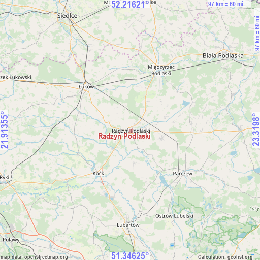
Radzyń Podlaski GPS coordinates[2]
51° 46' 59.988" North, 22° 37' 0.012" East
| Map corner | latitude | longitude |
|---|---|---|
| Upper-left | 52.21621°, | 21.91355° |
| Center: | 51.78333°, | 22.61667° |
| Lower-right: | 51.34625°, | 23.3198° |
| Map W x H: | 96.7×96.7 km | = 60.1×60.1mi |
| max Lat: | 54.83135° ⇑38.2% North |
| Radzyń Podlaski: | 51.78333° |
| min Lat: | ⇓61.8% South 49.21328° |
| min Long | Radzyń Podlask | max Long |
| 14.20249° | 22.61667° | 24.03723° |
| W 92.9%⇐ | ⇒7.1% E |
Elevation
Elevation of Radzyń Podlaski is 144 m = 472 ft, and this is 47.4 m = 156 ft below average elevation for this country.
| Max E: |
974 m = 3196 ft | 61.1% |
| Avg. | 191.4 m = 628 ft | |
| Radzyń Podlaski | 144 m = 472 ft | |
Min E: |
-3 m = -10 ft | 38.9% |
See also: Poland elevation on elevation.city.
Geographical zone
Radzyń Podlaski is located in North temperate zone (between Tropic of Cancer and the Arctic Circle). Distance of this North polar circle is 1643.4 km =1021.2 mi to North.| Distance of | km | miles | from Radzyń Podlaski |
|---|---|---|---|
| North Pole | 4249.3 | 2640.4 | to North |
| Arctic Circle | 1643.4 | 1021.2 | to North |
| Tropic Cancer | 3151.8 | 1958.4 | to South |
| Equator | 5757.8 | 3577.7 | to South |


Nearby cities:
15 places around Radzyń Podlaski: (largest is in red/bold)
• Borki
9.5 km =5.9 mi,  223°
223°
• Bystrzyca
20.9 km =13 mi,  267°
267°
• Czemierniki
12.4 km =7.7 mi,  172°
172°
• Drelów
22.6 km =14 mi,  50°
50°
• Kock
19.9 km =12.4 mi, 216°
• Komarówka Podlaska
22.6 km =14 mi,  84°
84°
• Kostry
22.7 km =14.1 mi,  115°
115°
• Kąkolewnica Wschodnia
14.8 km =9.2 mi,  24°
24°
• Milanów
20.7 km =12.9 mi, 115°
• Ostrówek
22.4 km =13.9 mi,  180°
180°
• Rzeczyca
21.9 km =13.6 mi, 24°
• Serokomla
21.6 km =13.4 mi,  244°
244°
• Siemień
20.3 km =12.6 mi,  148°
148°
• Wohyń
12 km =7.5 mi,  104°
104°
• Wojcieszków
20.8 km =12.9 mi, 265°
Sources, notices
• [Note1] Compared only with cities in Poland existing in our database
• [Src1] Map data: © OpenStreetMap contributors (CC-BY-SA)
• [Src2] Other city data from geonames.org with taken over terms of usage.
• [Src3] Geographical zone / Annual Mean Temperature by Robert A. Rohde @ Wikipedia
