Wohyń geodata
Wohyń (Lublin) is a populated place; located in Poland in Europe/Warsaw (GMT+2) time zone. With population of 2,000 people, there are 1469 cities with bigger population in this country. Compared to other cities in Poland, 61.2% of cities are located further ↓South; 94.5% of cities are located further ←West and 56.7% of cities have higher elevation than Wohyń. Note1


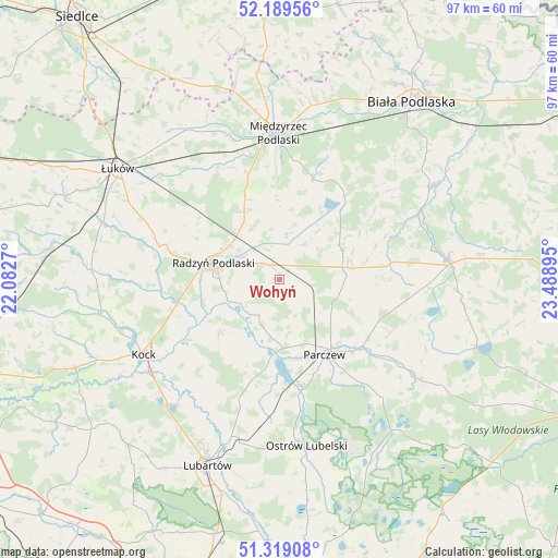
Wohyń GPS coordinates[2]
51° 45' 23.112" North, 22° 47' 8.952" East
| Map corner | latitude | longitude |
|---|---|---|
| Upper-left | 52.18956°, | 22.0827° |
| Center: | 51.75642°, | 22.78582° |
| Lower-right: | 51.31908°, | 23.48895° |
| Map W x H: | 96.8×96.8 km | = 60.1×60.1mi |
| max Lat: | 54.83135° ⇑38.8% North |
| Wohyń: | 51.75642° |
| min Lat: | ⇓61.2% South 49.21328° |
| min Long | Wohyń | max Long |
| 14.20249° | 22.78582° | 24.03723° |
| W 94.5%⇐ | ⇒5.5% E |
Elevation
Elevation of Wohyń is 154 m = 505 ft, and this is 37.4 m = 123 ft below average elevation for this country.
| Max E: |
974 m = 3196 ft | 56.7% |
| Avg. | 191.4 m = 628 ft | |
| Wohyń | 154 m = 505 ft | |
Min E: |
-3 m = -10 ft | 43.3% |
See also: Poland elevation on elevation.city.
Geographical zone
Wohyń is located in North temperate zone (between Tropic of Cancer and the Arctic Circle). Distance of this North polar circle is 1646.4 km =1023 mi to North.| Distance of | km | miles | from Wohyń |
|---|---|---|---|
| North Pole | 4252.3 | 2642.3 | to North |
| Arctic Circle | 1646.4 | 1023 | to North |
| Tropic Cancer | 3148.9 | 1956.6 | to South |
| Equator | 5754.8 | 3575.9 | to South |


Nearby cities:
15 places around Wohyń: (largest is in red/bold)
• Borki
18.6 km =11.6 mi,  258°
258°
• Czemierniki
13.7 km =8.5 mi,  227°
227°
• Drelów
18.3 km =11.4 mi,  18°
18°
• Dębowa Kłoda
23.6 km =14.7 mi,  139°
139°
• Jabłoń
21.1 km =13.1 mi,  99°
99°
• Komarówka Podlaska
12.1 km =7.5 mi,  64°
64°
• Kostry
11.2 km =7 mi,  126°
126°
• Kąkolewnica Wschodnia
17.3 km =10.7 mi,  341°
341°
• Milanów
9.2 km =5.7 mi, 129°
• Niedźwiada
24.5 km =15.2 mi,  195°
195°
• Ostrówek
22.8 km =14.2 mi,  211°
211°
• Parczew
15.1 km =9.4 mi,  148°
148°
• Radzyń Podlaski
12 km =7.5 mi,  284°
284°
• Rzeczyca
23 km =14.3 mi,  353°
353°
• Siemień
14.2 km =8.8 mi,  183°
183°
Sources, notices
• [Note1] Compared only with cities in Poland existing in our database
• [Src1] Map data: © OpenStreetMap contributors (CC-BY-SA)
• [Src2] Other city data from geonames.org with taken over terms of usage.
• [Src3] Geographical zone / Annual Mean Temperature by Robert A. Rohde @ Wikipedia
