Leżajsk geodata
Leżajsk (Subcarpathian) is a seat of a second-order administrative division; located in Poland in Europe/Warsaw (GMT+2) time zone. With population of 13,958 people, there are 355 cities with bigger population in this country. Compared to other cities in Poland, 72.9% of cities are located further ↑North; 90.5% of cities are located further ←West and 52.3% of cities have lower elevation than Leżajsk. Note1


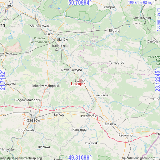
Leżajsk GPS coordinates[2]
50° 15' 45.252" North, 22° 25' 9.552" East
| Map corner | latitude | longitude |
|---|---|---|
| Upper-left | 50.70994°, | 21.7162° |
| Center: | 50.26257°, | 22.41932° |
| Lower-right: | 49.81096°, | 23.12245° |
| Map W x H: | 100×100 km | = 62.1×62.1mi |
| max Lat: | 54.83135° ⇑72.9% North |
| Leżajsk: | 50.26257° |
| min Lat: | ⇓27.1% South 49.21328° |
| min Long | Leżajsk | max Long |
| 14.20249° | 22.41932° | 24.03723° |
| W 90.5%⇐ | ⇒9.5% E |
Elevation
Elevation of Leżajsk is 178 m = 584 ft, and this is 13.4 m = 44 ft below average elevation for this country.
| Max E: |
974 m = 3196 ft | 47.7% |
| Avg. | 191.4 m = 628 ft | |
| Leżajsk | 178 m = 584 ft | |
Min E: |
-3 m = -10 ft | 52.3% |
See also: Poland elevation on elevation.city.
Geographical zone
Leżajsk is located in North temperate zone (between Tropic of Cancer and the Arctic Circle). Distance of this North polar circle is 1812.5 km =1126.2 mi to North.| Distance of | km | miles | from Leżajsk |
|---|---|---|---|
| North Pole | 4418.4 | 2745.5 | to North |
| Arctic Circle | 1812.5 | 1126.2 | to North |
| Tropic Cancer | 2982.8 | 1853.4 | to South |
| Equator | 5588.7 | 3472.7 | to South |


Nearby cities:
15 places around Leżajsk: (largest is in red/bold)
• Brzóza Królewska
7.2 km =4.5 mi,  248°
248°
• Brzóza Stadnicka
12 km =7.5 mi,  234°
234°
• Dębno
10.1 km =6.3 mi,  135°
135°
• Giedlarowa
4.1 km =2.5 mi,  193°
193°
• Grodzisko Dolne
11.6 km =7.2 mi,  164°
164°
• Grodzisko Górne
8.5 km =5.3 mi,  171°
171°
• Hucisko
8.7 km =5.4 mi,  280°
280°
• Kuryłówka
5.3 km =3.3 mi,  38°
38°
• Nowa Sarzyna
8.4 km =5.2 mi,  320°
320°
• Piskorowice
8.3 km =5.2 mi,  110°
110°
• Przychojec
4.2 km =2.6 mi,  342°
342°
• Stare Miasto
3 km =1.9 mi,  13°
13°
• Wierzawice
3.7 km =2.3 mi, 142°
• Wólka Grodziska
8.3 km =5.2 mi, 188°
• Łukowa
7.8 km =4.8 mi,  333°
333°
Sources, notices
• [Note1] Compared only with cities in Poland existing in our database
• [Src1] Map data: © OpenStreetMap contributors (CC-BY-SA)
• [Src2] Other city data from geonames.org with taken over terms of usage.
• [Src3] Geographical zone / Annual Mean Temperature by Robert A. Rohde @ Wikipedia
