Giedlarowa geodata
Giedlarowa (Subcarpathian) is a populated place; located in Poland in Europe/Warsaw (GMT+2) time zone. With population of 4,096 people, there are 799 cities with bigger population in this country. Compared to other cities in Poland, 73.9% of cities are located further ↑North; 90.2% of cities are located further ←West and 57.5% of cities have lower elevation than Giedlarowa. Note1


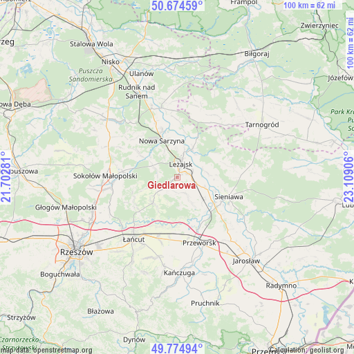
Giedlarowa GPS coordinates[2]
50° 13' 36.804" North, 22° 24' 21.348" East
| Map corner | latitude | longitude |
|---|---|---|
| Upper-left | 50.67459°, | 21.70281° |
| Center: | 50.22689°, | 22.40593° |
| Lower-right: | 49.77494°, | 23.10906° |
| Map W x H: | 100×100 km | = 62.1×62.1mi |
| max Lat: | 54.83135° ⇑73.9% North |
| Giedlarowa: | 50.22689° |
| min Lat: | ⇓26.1% South 49.21328° |
| min Long | Giedlarowa | max Long |
| 14.20249° | 22.40593° | 24.03723° |
| W 90.2%⇐ | ⇒9.8% E |
Elevation
Elevation of Giedlarowa is 192 m = 630 ft, and this is 0.59999999999999 m = 2 ft above average elevation for this country.
| Max E: |
974 m = 3196 ft | 42.5% |
| Giedlarowa | 192 m 630 ft | |
| Avg. | 191.4 m = 628 ft | |
Min E: |
-3 m = -10 ft | 57.5% |
See also: Poland elevation on elevation.city.
Geographical zone
Giedlarowa is located in North temperate zone (between Tropic of Cancer and the Arctic Circle). Distance of this North polar circle is 1816.5 km =1128.7 mi to North.| Distance of | km | miles | from Giedlarowa |
|---|---|---|---|
| North Pole | 4422.4 | 2748 | to North |
| Arctic Circle | 1816.5 | 1128.7 | to North |
| Tropic Cancer | 2978.8 | 1850.9 | to South |
| Equator | 5584.7 | 3470.2 | to South |


Nearby cities:
15 places around Giedlarowa: (largest is in red/bold)
• Brzóza Królewska
5.9 km =3.7 mi,  283°
283°
• Brzóza Stadnicka
9.3 km =5.8 mi,  250°
250°
• Dębno
8.6 km =5.3 mi,  111°
111°
• Grodzisko Dolne
8.2 km =5.1 mi,  150°
150°
• Grodzisko Górne
5 km =3.1 mi, 152°
• Hucisko
9.4 km =5.8 mi,  306°
306°
• Kuryłówka
9.2 km =5.7 mi,  27°
27°
• Leżajsk
4.1 km =2.5 mi,  13°
13°
• Piskorowice
8.8 km =5.5 mi,  83°
83°
• Przychojec
7.9 km =4.9 mi,  357°
357°
• Stare Miasto
7.1 km =4.4 mi, 13°
• Wierzawice
3.4 km =2.1 mi,  72°
72°
• Wólka Grodziska
4.2 km =2.6 mi,  183°
183°
• Łukowa
11.2 km =7 mi,  346°
346°
• Żołynia
10 km =6.2 mi,  223°
223°
Sources, notices
• [Note1] Compared only with cities in Poland existing in our database
• [Src1] Map data: © OpenStreetMap contributors (CC-BY-SA)
• [Src2] Other city data from geonames.org with taken over terms of usage.
• [Src3] Geographical zone / Annual Mean Temperature by Robert A. Rohde @ Wikipedia
