Kuryłówka geodata
Kuryłówka (Subcarpathian) is a seat of a third-order administrative division; located in Poland in Europe/Warsaw (GMT+2) time zone. With population of 1,674 people, there are 1710 cities with bigger population in this country. Compared to other cities in Poland, 72.1% of cities are located further ↑North; 91.2% of cities are located further ←West and 50.8% of cities have higher elevation than Kuryłówka. Note1


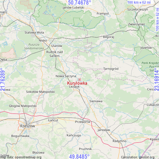
Kuryłówka GPS coordinates[2]
50° 17' 59.136" North, 22° 27' 57.636" East
| Map corner | latitude | longitude |
|---|---|---|
| Upper-left | 50.74678°, | 21.76289° |
| Center: | 50.29976°, | 22.46601° |
| Lower-right: | 49.8485°, | 23.16914° |
| Map W x H: | 99.9×99.9 km | = 62.1×62.1mi |
| max Lat: | 54.83135° ⇑72.1% North |
| Kuryłówka: | 50.29976° |
| min Lat: | ⇓27.9% South 49.21328° |
| min Long | Kuryłówka | max Long |
| 14.20249° | 22.46601° | 24.03723° |
| W 91.2%⇐ | ⇒8.8% E |
Elevation
Elevation of Kuryłówka is 170 m = 558 ft, and this is 21.4 m = 70 ft below average elevation for this country.
| Max E: |
974 m = 3196 ft | 50.8% |
| Avg. | 191.4 m = 628 ft | |
| Kuryłówka | 170 m = 558 ft | |
Min E: |
-3 m = -10 ft | 49.2% |
See also: Poland elevation on elevation.city.
Geographical zone
Kuryłówka is located in North temperate zone (between Tropic of Cancer and the Arctic Circle). Distance of this North polar circle is 1808.4 km =1123.7 mi to North.| Distance of | km | miles | from Kuryłówka |
|---|---|---|---|
| North Pole | 4414.3 | 2742.9 | to North |
| Arctic Circle | 1808.4 | 1123.7 | to North |
| Tropic Cancer | 2986.9 | 1856 | to South |
| Equator | 5592.8 | 3475.2 | to South |


Nearby cities:
15 places around Kuryłówka: (largest is in red/bold)
• Brzóza Królewska
12 km =7.5 mi,  235°
235°
• Bystre
10.1 km =6.3 mi,  330°
330°
• Dębno
11.9 km =7.4 mi,  161°
161°
• Giedlarowa
9.2 km =5.7 mi,  207°
207°
• Grodzisko Górne
12.7 km =7.9 mi,  189°
189°
• Hucisko
12.1 km =7.5 mi,  258°
258°
• Leżajsk
5.3 km =3.3 mi,  218°
218°
• Nowa Sarzyna
8.9 km =5.5 mi,  285°
285°
• Piskorowice
8.4 km =5.2 mi,  147°
147°
• Potok Górny
11.6 km =7.2 mi,  35°
35°
• Przychojec
4.6 km =2.9 mi,  267°
267°
• Stare Miasto
2.9 km =1.8 mi, 244°
• Tarnogóra
13 km =8.1 mi,  306°
306°
• Wierzawice
7.1 km =4.4 mi, 188°
• Łukowa
7.4 km =4.6 mi, 292°
Sources, notices
• [Note1] Compared only with cities in Poland existing in our database
• [Src1] Map data: © OpenStreetMap contributors (CC-BY-SA)
• [Src2] Other city data from geonames.org with taken over terms of usage.
• [Src3] Geographical zone / Annual Mean Temperature by Robert A. Rohde @ Wikipedia
