Szepietowo geodata
Szepietowo (Podlasie) is a seat of a third-order administrative division; located in Poland in Europe/Warsaw (GMT+2) time zone. With population of 2,335 people, there are 1313 cities with bigger population in this country. Compared to other cities in Poland, 81.8% of cities are located further ↓South; 92.1% of cities are located further ←West and 59.5% of cities have higher elevation than Szepietowo. Note1


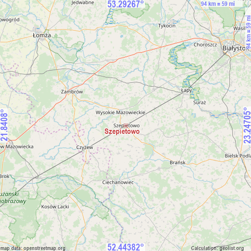
Szepietowo GPS coordinates[2]
52° 52' 13.152" North, 22° 32' 38.112" East
| Map corner | latitude | longitude |
|---|---|---|
| Upper-left | 53.29267°, | 21.8408° |
| Center: | 52.87032°, | 22.54392° |
| Lower-right: | 52.44382°, | 23.24705° |
| Map W x H: | 94.4×94.4 km | = 58.7×58.7mi |
| max Lat: | 54.83135° ⇑18.2% North |
| Szepietowo: | 52.87032° |
| min Lat: | ⇓81.8% South 49.21328° |
| min Long | Szepietowo | max Long |
| 14.20249° | 22.54392° | 24.03723° |
| W 92.1%⇐ | ⇒7.9% E |
Elevation
Elevation of Szepietowo is 148 m = 486 ft, and this is 43.4 m = 142 ft below average elevation for this country.
| Max E: |
974 m = 3196 ft | 59.5% |
| Avg. | 191.4 m = 628 ft | |
| Szepietowo | 148 m = 486 ft | |
Min E: |
-3 m = -10 ft | 40.5% |
See also: Poland elevation on elevation.city.
Geographical zone
Szepietowo is located in North temperate zone (between Tropic of Cancer and the Arctic Circle). Distance of this North polar circle is 1522.5 km =946 mi to North.| Distance of | km | miles | from Szepietowo |
|---|---|---|---|
| North Pole | 4128.4 | 2565.3 | to North |
| Arctic Circle | 1522.5 | 946 | to North |
| Tropic Cancer | 3272.7 | 2033.6 | to South |
| Equator | 5878.6 | 3652.8 | to South |


Nearby cities:
15 places around Szepietowo: (largest is in red/bold)
• Andrzejewo
23.3 km =14.5 mi,  259°
259°
• Boguty-Pianki
19.1 km =11.9 mi,  206°
206°
• Brańsk
24.2 km =15 mi,  125°
125°
• Ciechanowiec
21.6 km =13.4 mi,  188°
188°
• Czyżew
17.5 km =10.9 mi,  242°
242°
• Klukowo
10.7 km =6.6 mi, 193°
• Nur
27 km =16.8 mi, 213°
• Rudka
20.4 km =12.7 mi,  142°
142°
• Rutki
26.6 km =16.5 mi,  343°
343°
• Rutki-Kossaki
25.3 km =15.7 mi, 344°
• Sokoły
17.2 km =10.7 mi,  37°
37°
• Suraż
29 km =18 mi,  72°
72°
• Wysokie Mazowieckie
5.5 km =3.4 mi, 340°
• Zambrów
23.9 km =14.9 mi,  302°
302°
• Łapy
26.5 km =16.5 mi,  59°
59°
Sources, notices
• [Note1] Compared only with cities in Poland existing in our database
• [Src1] Map data: © OpenStreetMap contributors (CC-BY-SA)
• [Src2] Other city data from geonames.org with taken over terms of usage.
• [Src3] Geographical zone / Annual Mean Temperature by Robert A. Rohde @ Wikipedia
