Wysokie Mazowieckie geodata
Wysokie Mazowieckie (Podlasie) is a populated place; located in Poland in Europe/Warsaw (GMT+2) time zone. With population of 9,203 people, there are 471 cities with bigger population in this country. Compared to other cities in Poland, 82.6% of cities are located further ↓South; 91.9% of cities are located further ←West and 61.5% of cities have higher elevation than Wysokie Mazowieckie. Note1
Administrative division(s):
- Level 1: Podlasie
- Level 2: Powiat wysokomazowiecki
- Level 3: Wysokie Mazowieckie


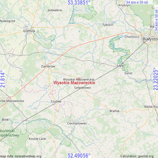
Wysokie Mazowieckie GPS coordinates[2]
52° 54' 59.796" North, 22° 31' 1.632" East
| Map corner | latitude | longitude |
|---|---|---|
| Upper-left | 53.33851°, | 21.814° |
| Center: | 52.91661°, | 22.51712° |
| Lower-right: | 52.49056°, | 23.22025° |
| Map W x H: | 94.3×94.3 km | = 58.6×58.6mi |
| max Lat: | 54.83135° ⇑17.4% North |
| Wysokie Mazowieckie: | 52.91661° |
| min Lat: | ⇓82.6% South 49.21328° |
| min Long | Wysokie Mazowie | max Long |
| 14.20249° | 22.51712° | 24.03723° |
| W 91.9%⇐ | ⇒8.1% E |
Elevation
Elevation of Wysokie Mazowieckie is 143 m = 469 ft, and this is 48.4 m = 159 ft below average elevation for this country.
| Max E: |
974 m = 3196 ft | 61.5% |
| Avg. | 191.4 m = 628 ft | |
| Wysokie Mazowieckie | 143 m = 469 ft | |
Min E: |
-3 m = -10 ft | 38.5% |
See also: Poland elevation on elevation.city.
Geographical zone
Wysokie Mazowieckie is located in North temperate zone (between Tropic of Cancer and the Arctic Circle). Distance of this North polar circle is 1517.4 km =942.9 mi to North.| Distance of | km | miles | from Wysokie Mazowieckie |
|---|---|---|---|
| North Pole | 4123.3 | 2562.1 | to North |
| Arctic Circle | 1517.4 | 942.9 | to North |
| Tropic Cancer | 3277.9 | 2036.8 | to South |
| Equator | 5883.8 | 3656 | to South |


Nearby cities:
15 places around Wysokie Mazowieckie: (largest is in red/bold)
• Andrzejewo
23.1 km =14.4 mi,  245°
245°
• Boguty-Pianki
23.2 km =14.4 mi,  197°
197°
• Brańsk
28.8 km =17.9 mi,  131°
131°
• Ciechanowiec
26.5 km =16.5 mi,  182°
182°
• Czyżew
19.1 km =11.9 mi,  226°
226°
• Gać
25.6 km =15.9 mi,  315°
315°
• Klukowo
15.6 km =9.7 mi, 182°
• Rudka
25.6 km =15.9 mi,  146°
146°
• Rutki
21.1 km =13.1 mi,  344°
344°
• Rutki-Kossaki
19.9 km =12.4 mi, 344°
• Sokoły
14.9 km =9.3 mi,  55°
55°
• Szepietowo
5.5 km =3.4 mi,  160°
160°
• Szumowo
29 km =18 mi,  270°
270°
• Zambrów
19.9 km =12.4 mi,  292°
292°
• Łapy
25.9 km =16.1 mi,  71°
71°
Sources, notices
• [Note1] Compared only with cities in Poland existing in our database
• [Src1] Map data: © OpenStreetMap contributors (CC-BY-SA)
• [Src2] Other city data from geonames.org with taken over terms of usage.
• [Src3] Geographical zone / Annual Mean Temperature by Robert A. Rohde @ Wikipedia
