Podegrodzie geodata
Podegrodzie (Lesser Poland) is a seat of a third-order administrative division; located in Poland in Europe/Warsaw (GMT+2) time zone. With population of 1,902 people, there are 1549 cities with bigger population in this country. Compared to other cities in Poland, 96.9% of cities are located further ↑North; 66.2% of cities are located further ←West and 88.1% of cities have lower elevation than Podegrodzie. Note1


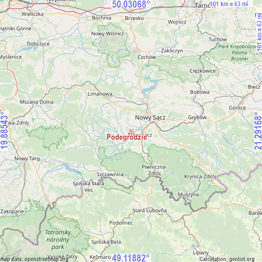
Podegrodzie GPS coordinates[2]
49° 34' 36.768" North, 20° 35' 18.78" East
| Map corner | latitude | longitude |
|---|---|---|
| Upper-left | 50.03068°, | 19.88543° |
| Center: | 49.57688°, | 20.58855° |
| Lower-right: | 49.11882°, | 21.29168° |
| Map W x H: | 101.4×101.4 km | = 63×63mi |
| max Lat: | 54.83135° ⇑96.9% North |
| Podegrodzie: | 49.57688° |
| min Lat: | ⇓3.1% South 49.21328° |
| min Long | Podegrodzie | max Long |
| 14.20249° | 20.58855° | 24.03723° |
| W 66.2%⇐ | ⇒33.8% E |
Elevation
Elevation of Podegrodzie is 309 m = 1014 ft, and this is 117.6 m = 386 ft above average elevation for this country.
| Max E: |
974 m = 3196 ft | 11.9% |
| Podegrodzie | 309 m 1014 ft | |
| Avg. | 191.4 m = 628 ft | |
Min E: |
-3 m = -10 ft | 88.1% |
See also: Poland elevation on elevation.city.
Geographical zone
Podegrodzie is located in North temperate zone (between Tropic of Cancer and the Arctic Circle). Distance of this North polar circle is 1888.7 km =1173.6 mi to North.| Distance of | km | miles | from Podegrodzie |
|---|---|---|---|
| North Pole | 4494.6 | 2792.8 | to North |
| Arctic Circle | 1888.7 | 1173.6 | to North |
| Tropic Cancer | 2906.5 | 1806 | to South |
| Equator | 5512.4 | 3425.2 | to South |


Nearby cities:
15 places around Podegrodzie: (largest is in red/bold)
• Chełmiec
8.1 km =5 mi,  42°
42°
• Jastrzębie
8.2 km =5.1 mi,  282°
282°
• Kamienica
17.6 km =10.9 mi,  269°
269°
• Kamionka Wielka
17 km =10.6 mi,  93°
93°
• Naszacowice
2.8 km =1.7 mi,  238°
238°
• Nawojowa
10.9 km =6.8 mi,  95°
95°
• Nowy Sącz
9.3 km =5.8 mi,  57°
57°
• Olszana
5 km =3.1 mi,  257°
257°
• Olszanka
4.1 km =2.5 mi, 235°
• Rytro
11.3 km =7 mi,  150°
150°
• Stary Sącz
3.7 km =2.3 mi,  113°
113°
• Wysokie
9.1 km =5.7 mi,  339°
339°
• Zagorzyn
13 km =8.1 mi, 270°
• Łukowica
8.5 km =5.3 mi,  296°
296°
• Łącko
11.2 km =7 mi, 258°
Sources, notices
• [Note1] Compared only with cities in Poland existing in our database
• [Src1] Map data: © OpenStreetMap contributors (CC-BY-SA)
• [Src2] Other city data from geonames.org with taken over terms of usage.
• [Src3] Geographical zone / Annual Mean Temperature by Robert A. Rohde @ Wikipedia
