Naszacowice geodata
Naszacowice (Lesser Poland) is a populated place; located in Poland in Europe/Warsaw (GMT+2) time zone. With population of 732 people, there are 3001 cities with bigger population in this country. Compared to other cities in Poland, 97.3% of cities are located further ↑North; 65.8% of cities are located further ←West and 90.3% of cities have lower elevation than Naszacowice. Note1


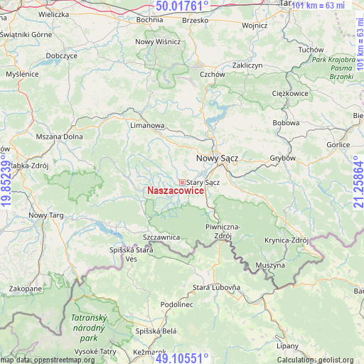
Naszacowice GPS coordinates[2]
49° 33' 49.284" North, 20° 33' 19.836" East
| Map corner | latitude | longitude |
|---|---|---|
| Upper-left | 50.01761°, | 19.85239° |
| Center: | 49.56369°, | 20.55551° |
| Lower-right: | 49.10551°, | 21.25864° |
| Map W x H: | 101.4×101.4 km | = 63×63mi |
| max Lat: | 54.83135° ⇑97.3% North |
| Naszacowice: | 49.56369° |
| min Lat: | ⇓2.7% South 49.21328° |
| min Long | Naszacowice | max Long |
| 14.20249° | 20.55551° | 24.03723° |
| W 65.8%⇐ | ⇒34.2% E |
Elevation
Elevation of Naszacowice is 333 m = 1093 ft, and this is 141.6 m = 465 ft above average elevation for this country.
| Max E: |
974 m = 3196 ft | 9.7% |
| Naszacowice | 333 m 1093 ft | |
| Avg. | 191.4 m = 628 ft | |
Min E: |
-3 m = -10 ft | 90.3% |
See also: Poland elevation on elevation.city.
Geographical zone
Naszacowice is located in North temperate zone (between Tropic of Cancer and the Arctic Circle). Distance of this North polar circle is 1890.2 km =1174.5 mi to North.| Distance of | km | miles | from Naszacowice |
|---|---|---|---|
| North Pole | 4496.1 | 2793.7 | to North |
| Arctic Circle | 1890.2 | 1174.5 | to North |
| Tropic Cancer | 2905 | 1805.1 | to South |
| Equator | 5511 | 3424.4 | to South |


Nearby cities:
15 places around Naszacowice: (largest is in red/bold)
• Chełmiec
10.8 km =6.7 mi,  46°
46°
• Jastrzębie
6.5 km =4 mi,  299°
299°
• Kamienica
15.2 km =9.4 mi,  274°
274°
• Nawojowa
13.3 km =8.3 mi,  88°
88°
• Nowy Sącz
12.1 km =7.5 mi,  57°
57°
• Ochotnica Dolna
15.9 km =9.9 mi,  255°
255°
• Olszana
2.5 km =1.6 mi,  279°
279°
• Olszanka
1.3 km =0.8 mi,  229°
229°
• Podegrodzie
2.8 km =1.7 mi, 58°
• Rytro
11.5 km =7.1 mi,  136°
136°
• Stary Sącz
5.7 km =3.5 mi, 90°
• Wysokie
10.1 km =6.3 mi,  355°
355°
• Zagorzyn
10.8 km =6.7 mi, 278°
• Łukowica
7.4 km =4.6 mi,  315°
315°
• Łącko
8.7 km =5.4 mi, 265°
Sources, notices
• [Note1] Compared only with cities in Poland existing in our database
• [Src1] Map data: © OpenStreetMap contributors (CC-BY-SA)
• [Src2] Other city data from geonames.org with taken over terms of usage.
• [Src3] Geographical zone / Annual Mean Temperature by Robert A. Rohde @ Wikipedia
