Łukowica geodata
Łukowica (Lesser Poland) is a seat of a third-order administrative division; located in Poland in Europe/Warsaw (GMT+2) time zone. With population of 2,220 people, there are 1351 cities with bigger population in this country. Compared to other cities in Poland, 96.4% of cities are located further ↑North; 64.9% of cities are located further ←West and 96.7% of cities have lower elevation than Łukowica. Note1


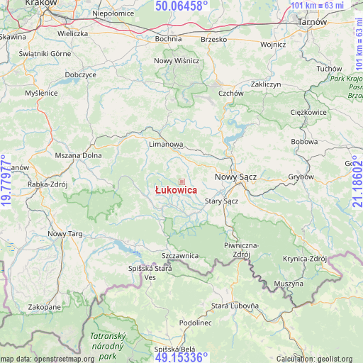
Łukowica GPS coordinates[2]
49° 36' 39.96" North, 20° 28' 58.404" East
| Map corner | latitude | longitude |
|---|---|---|
| Upper-left | 50.06458°, | 19.77977° |
| Center: | 49.6111°, | 20.48289° |
| Lower-right: | 49.15336°, | 21.18602° |
| Map W x H: | 101.3×101.3 km | = 62.9×62.9mi |
| max Lat: | 54.83135° ⇑96.4% North |
| Łukowica: | 49.6111° |
| min Lat: | ⇓3.6% South 49.21328° |
| min Long | Łukowica | max Long |
| 14.20249° | 20.48289° | 24.03723° |
| W 64.9%⇐ | ⇒35.1% E |
Elevation
Elevation of Łukowica is 463 m = 1519 ft, and this is 271.6 m = 891 ft above average elevation for this country.
| Max E: |
974 m = 3196 ft | 3.3% |
| Łukowica | 463 m 1519 ft | |
| Avg. | 191.4 m = 628 ft | |
Min E: |
-3 m = -10 ft | 96.7% |
See also: Poland elevation on elevation.city.
Geographical zone
Łukowica is located in North temperate zone (between Tropic of Cancer and the Arctic Circle). Distance of this North polar circle is 1884.9 km =1171.2 mi to North.| Distance of | km | miles | from Łukowica |
|---|---|---|---|
| North Pole | 4490.8 | 2790.5 | to North |
| Arctic Circle | 1884.9 | 1171.2 | to North |
| Tropic Cancer | 2910.3 | 1808.4 | to South |
| Equator | 5516.2 | 3427.6 | to South |


Nearby cities:
15 places around Łukowica: (largest is in red/bold)
• Chełmiec
13.2 km =8.2 mi,  80°
80°
• Jastrzębie
2.1 km =1.3 mi,  190°
190°
• Kamienica
10.7 km =6.6 mi,  248°
248°
• Limanowa
11.4 km =7.1 mi,  337°
337°
• Naszacowice
7.4 km =4.6 mi,  135°
135°
• Nowy Sącz
15.5 km =9.6 mi,  85°
85°
• Ochotnica Dolna
13.8 km =8.6 mi,  227°
227°
• Olszana
5.6 km =3.5 mi,  150°
150°
• Olszanka
7.4 km =4.6 mi, 145°
• Podegrodzie
8.5 km =5.3 mi,  116°
116°
• Stary Sącz
12.2 km =7.6 mi, 115°
• Słopnice
13 km =8.1 mi,  309°
309°
• Wysokie
6.5 km =4 mi,  42°
42°
• Zagorzyn
6.6 km =4.1 mi,  235°
235°
• Łącko
6.8 km =4.2 mi,  209°
209°
Sources, notices
• [Note1] Compared only with cities in Poland existing in our database
• [Src1] Map data: © OpenStreetMap contributors (CC-BY-SA)
• [Src2] Other city data from geonames.org with taken over terms of usage.
• [Src3] Geographical zone / Annual Mean Temperature by Robert A. Rohde @ Wikipedia
