Łochów geodata
Łochów (Mazovia) is a seat of a third-order administrative division; located in Poland in Europe/Warsaw (GMT+2) time zone. With population of 6,486 people, there are 573 cities with bigger population in this country. Compared to other cities in Poland, 77% of cities are located further ↓South; 81.2% of cities are located further ←West and 81.2% of cities have higher elevation than Łochów. Note1


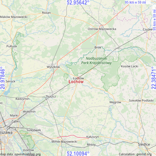
Łochów GPS coordinates[2]
52° 31' 50.736" North, 21° 40' 53.688" East
| Map corner | latitude | longitude |
|---|---|---|
| Upper-left | 52.95642°, | 20.97846° |
| Center: | 52.53076°, | 21.68158° |
| Lower-right: | 52.10094°, | 22.38471° |
| Map W x H: | 95.1×95.1 km | = 59.1×59.1mi |
| max Lat: | 54.83135° ⇑23% North |
| Łochów: | 52.53076° |
| min Lat: | ⇓77% South 49.21328° |
| min Long | Łochów | max Long |
| 14.20249° | 21.68158° | 24.03723° |
| W 81.2%⇐ | ⇒18.8% E |
Elevation
Elevation of Łochów is 97 m = 318 ft, and this is 94.4 m = 310 ft below average elevation for this country.
| Max E: |
974 m = 3196 ft | 81.2% |
| Avg. | 191.4 m = 628 ft | |
| Łochów | 97 m = 318 ft | |
Min E: |
-3 m = -10 ft | 18.8% |
See also: Poland elevation on elevation.city.
Geographical zone
Łochów is located in North temperate zone (between Tropic of Cancer and the Arctic Circle). Distance of this North polar circle is 1560.3 km =969.5 mi to North.| Distance of | km | miles | from Łochów |
|---|---|---|---|
| North Pole | 4166.2 | 2588.8 | to North |
| Arctic Circle | 1560.3 | 969.5 | to North |
| Tropic Cancer | 3235 | 2010.1 | to South |
| Equator | 5840.9 | 3629.4 | to South |


Nearby cities:
15 places around Łochów: (largest is in red/bold)
• Brańszczyk
12.7 km =7.9 mi,  329°
329°
• Brok
22.2 km =13.8 mi,  32°
32°
• Dobre
23.3 km =14.5 mi,  180°
180°
• Jadów
6.7 km =4.2 mi,  210°
210°
• Jasienica
22.4 km =13.9 mi,  234°
234°
• Korytnica
17.2 km =10.7 mi,  138°
138°
• Liw
26 km =16.2 mi,  131°
131°
• Ostrówek
5.9 km =3.7 mi,  64°
64°
• Rybno
19 km =11.8 mi,  282°
282°
• Sadowne
16.5 km =10.3 mi,  42°
42°
• Stoczek
14.8 km =9.2 mi,  84°
84°
• Strachówka
12 km =7.5 mi,  195°
195°
• Tłuszcz
20 km =12.4 mi,  236°
236°
• Wyszków
16.6 km =10.3 mi,  294°
294°
• Zabrodzie
17.9 km =11.1 mi,  262°
262°
Sources, notices
• [Note1] Compared only with cities in Poland existing in our database
• [Src1] Map data: © OpenStreetMap contributors (CC-BY-SA)
• [Src2] Other city data from geonames.org with taken over terms of usage.
• [Src3] Geographical zone / Annual Mean Temperature by Robert A. Rohde @ Wikipedia
