Ostrówek geodata
Ostrówek (Mazovia) is a populated place; located in Poland in Europe/Warsaw (GMT+2) time zone. With population of 1,700 people, there are 1678 cities with bigger population in this country. Compared to other cities in Poland, 77.2% of cities are located further ↓South; 81.9% of cities are located further ←West and 77.2% of cities have higher elevation than Ostrówek. Note1


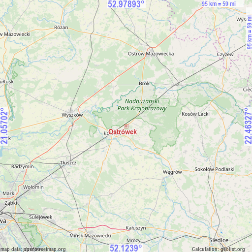
Ostrówek GPS coordinates[2]
52° 33' 12.6" North, 21° 45' 36.504" East
| Map corner | latitude | longitude |
|---|---|---|
| Upper-left | 52.97893°, | 21.05702° |
| Center: | 52.5535°, | 21.76014° |
| Lower-right: | 52.1239°, | 22.46327° |
| Map W x H: | 95.1×95.1 km | = 59.1×59.1mi |
| max Lat: | 54.83135° ⇑22.8% North |
| Ostrówek: | 52.5535° |
| min Lat: | ⇓77.2% South 49.21328° |
| min Long | Ostrówek | max Long |
| 14.20249° | 21.76014° | 24.03723° |
| W 81.9%⇐ | ⇒18.1% E |
Elevation
Elevation of Ostrówek is 105 m = 344 ft, and this is 86.4 m = 283 ft below average elevation for this country.
| Max E: |
974 m = 3196 ft | 77.2% |
| Avg. | 191.4 m = 628 ft | |
| Ostrówek | 105 m = 344 ft | |
Min E: |
-3 m = -10 ft | 22.8% |
See also: Poland elevation on elevation.city.
Geographical zone
Ostrówek is located in North temperate zone (between Tropic of Cancer and the Arctic Circle). Distance of this North polar circle is 1557.8 km =968 mi to North.| Distance of | km | miles | from Ostrówek |
|---|---|---|---|
| North Pole | 4163.7 | 2587.2 | to North |
| Arctic Circle | 1557.8 | 968 | to North |
| Tropic Cancer | 3237.5 | 2011.7 | to South |
| Equator | 5843.4 | 3630.9 | to South |


Nearby cities:
15 places around Ostrówek: (largest is in red/bold)
• Brańszczyk
14.4 km =8.9 mi,  305°
305°
• Brok
17.5 km =10.9 mi,  21°
21°
• Jadów
12 km =7.5 mi,  226°
226°
• Korytnica
16.6 km =10.3 mi,  158°
158°
• Liw
24.3 km =15.1 mi,  144°
144°
• Małkinia Górna
23.8 km =14.8 mi,  49°
49°
• Miedzna
24.2 km =15 mi,  113°
113°
• Rybno
23.9 km =14.9 mi,  274°
274°
• Sadowne
11.3 km =7 mi,  30°
30°
• Stoczek
9.5 km =5.9 mi,  96°
96°
• Strachówka
16.4 km =10.2 mi,  211°
211°
• Wyszków
20.9 km =13 mi,  282°
282°
• Węgrów
24.4 km =15.2 mi,  134°
134°
• Zabrodzie
23.6 km =14.7 mi,  258°
258°
• Łochów
5.9 km =3.7 mi,  244°
244°
Sources, notices
• [Note1] Compared only with cities in Poland existing in our database
• [Src1] Map data: © OpenStreetMap contributors (CC-BY-SA)
• [Src2] Other city data from geonames.org with taken over terms of usage.
• [Src3] Geographical zone / Annual Mean Temperature by Robert A. Rohde @ Wikipedia
