Długosiodło geodata
Długosiodło (Mazovia) is a populated place; located in Poland in Europe/Warsaw (GMT+2) time zone. With population of 2,020 people, there are 1457 cities with bigger population in this country. Compared to other cities in Poland, 80.3% of cities are located further ↓South; 80.2% of cities are located further ←West and 78.8% of cities have higher elevation than Długosiodło. Note1


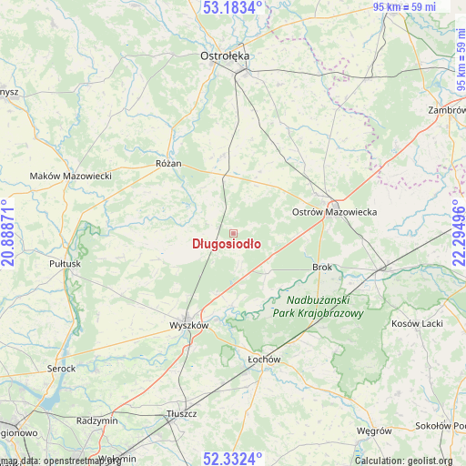
Długosiodło GPS coordinates[2]
52° 45' 35.928" North, 21° 35' 30.588" East
| Map corner | latitude | longitude |
|---|---|---|
| Upper-left | 53.1834°, | 20.88871° |
| Center: | 52.75998°, | 21.59183° |
| Lower-right: | 52.3324°, | 22.29496° |
| Map W x H: | 94.6×94.6 km | = 58.8×58.8mi |
| max Lat: | 54.83135° ⇑19.7% North |
| Długosiodło: | 52.75998° |
| min Lat: | ⇓80.3% South 49.21328° |
| min Long | Długosiodło | max Long |
| 14.20249° | 21.59183° | 24.03723° |
| W 80.2%⇐ | ⇒19.8% E |
Elevation
Elevation of Długosiodło is 102 m = 335 ft, and this is 89.4 m = 293 ft below average elevation for this country.
| Max E: |
974 m = 3196 ft | 78.8% |
| Avg. | 191.4 m = 628 ft | |
| Długosiodło | 102 m = 335 ft | |
Min E: |
-3 m = -10 ft | 21.2% |
See also: Poland elevation on elevation.city.
Geographical zone
Długosiodło is located in North temperate zone (between Tropic of Cancer and the Arctic Circle). Distance of this North polar circle is 1534.8 km =953.7 mi to North.| Distance of | km | miles | from Długosiodło |
|---|---|---|---|
| North Pole | 4140.7 | 2572.9 | to North |
| Arctic Circle | 1534.8 | 953.7 | to North |
| Tropic Cancer | 3260.4 | 2025.9 | to South |
| Equator | 5866.4 | 3645.2 | to South |


Nearby cities:
15 places around Długosiodło: (largest is in red/bold)
• Brańszczyk
14.5 km =9 mi,  181°
181°
• Brok
19.1 km =11.9 mi,  110°
110°
• Czerwin
23.8 km =14.8 mi,  28°
28°
• Goworowo
15.8 km =9.8 mi,  351°
351°
• Młynarze
24.8 km =15.4 mi,  330°
330°
• Obryte
23.6 km =14.7 mi,  258°
258°
• Ostrów Mazowiecka
20.9 km =13 mi,  76°
76°
• Ostrówek
25.6 km =15.9 mi,  153°
153°
• Rybno
24.6 km =15.3 mi,  210°
210°
• Rzewnie
19.1 km =11.9 mi,  295°
295°
• Rząśnik
16 km =9.9 mi,  251°
251°
• Różan
19.6 km =12.2 mi,  316°
316°
• Sadowne
21.6 km =13.4 mi,  127°
127°
• Wyszków
20.7 km =12.9 mi, 205°
• Wąsewo
13.8 km =8.6 mi,  23°
23°
Sources, notices
• [Note1] Compared only with cities in Poland existing in our database
• [Src1] Map data: © OpenStreetMap contributors (CC-BY-SA)
• [Src2] Other city data from geonames.org with taken over terms of usage.
• [Src3] Geographical zone / Annual Mean Temperature by Robert A. Rohde @ Wikipedia
