Krasna geodata
Krasna (Subcarpathian) is a populated place; located in Poland in Europe/Warsaw (GMT+2) time zone. With population of 661 people, there are 3141 cities with bigger population in this country. Compared to other cities in Poland, 92.6% of cities are located further ↑North; 82.8% of cities are located further ←West and 84.2% of cities have lower elevation than Krasna. Note1


Krasna GPS coordinates[2]
49° 46' 32.988" North, 21° 51' 10.836" East
| Map corner | latitude | longitude |
|---|---|---|
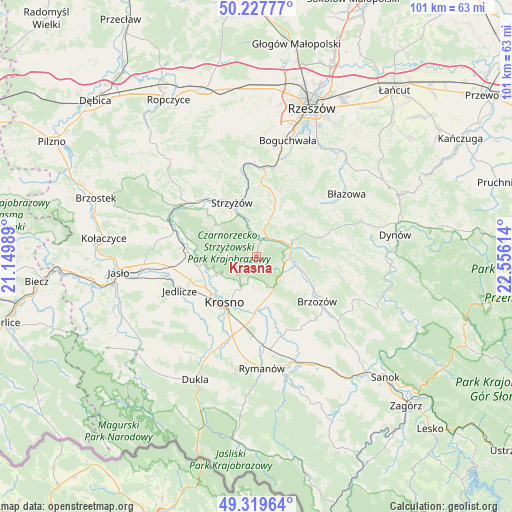
| Upper-left | 50.22777°, | 21.14989° |
| Center: | 49.77583°, | 21.85301° |
| Lower-right: | 49.31964°, | 22.55614° |
| Map W x H: | 101×101 km | = 62.8×62.8mi |
| max Lat: | 54.83135° ⇑92.6% North |
| Krasna: | 49.77583° |
| min Lat: | ⇓7.4% South 49.21328° |
| min Long | Krasna | max Long |
| 14.20249° | 21.85301° | 24.03723° |
| W 82.8%⇐ | ⇒17.2% E |
Elevation
Elevation of Krasna is 286 m = 938 ft, and this is 94.6 m = 310 ft above average elevation for this country.
| Max E: |
974 m = 3196 ft | 15.8% |
| Krasna | 286 m 938 ft | |
| Avg. | 191.4 m = 628 ft | |
Min E: |
-3 m = -10 ft | 84.2% |
See also: Poland elevation on elevation.city.
Geographical zone
Krasna is located in North temperate zone (between Tropic of Cancer and the Arctic Circle). Distance of this North polar circle is 1866.6 km =1159.9 mi to North.| Distance of | km | miles | from Krasna |
|---|---|---|---|
| North Pole | 4472.5 | 2779.1 | to North |
| Arctic Circle | 1866.6 | 1159.9 | to North |
| Tropic Cancer | 2928.6 | 1819.7 | to South |
| Equator | 5534.6 | 3439 | to South |


Nearby cities:
15 places around Krasna: (largest is in red/bold)
• Blizne
9 km =5.6 mi,  106°
106°
• Domaradz
6.8 km =4.2 mi,  79°
79°
• Jabłonica Polska
9.3 km =5.8 mi,  158°
158°
• Jasienica Rosielna
6.9 km =4.3 mi, 113°
• Jawornik
8.4 km =5.2 mi,  20°
20°
• Konieczkowa
9.1 km =5.7 mi,  36°
36°
• Korczyna
7.4 km =4.6 mi,  205°
205°
• Krosno
11.4 km =7.1 mi, 211°
• Krościenko Wyżne
10.9 km =6.8 mi,  189°
189°
• Malinówka
10.3 km =6.4 mi,  148°
148°
• Niebylec
9.7 km =6 mi, 21°
• Odrzykoń
9 km =5.6 mi,  244°
244°
• Orzechówka
8.3 km =5.2 mi,  127°
127°
• Strzyżów
11.4 km =7.1 mi,  338°
338°
• Wysoka Strzyżowska
10.1 km =6.3 mi,  307°
307°
Sources, notices
• [Note1] Compared only with cities in Poland existing in our database
• [Src1] Map data: © OpenStreetMap contributors (CC-BY-SA)
• [Src2] Other city data from geonames.org with taken over terms of usage.
• [Src3] Geographical zone / Annual Mean Temperature by Robert A. Rohde @ Wikipedia
