Cayuco geodata
Cayuco (Utuado) is a populated place; located in Puerto Rico in America/Puerto_Rico (GMT-4) time zone. With population of 1,284 people, there are 190 cities with bigger population in this country. Compared to other cities in Puerto Rico, 56.4% of cities are located further ↓South; 74.2% of cities are located further →East and 94.2% of cities have lower elevation than Cayuco. Note1


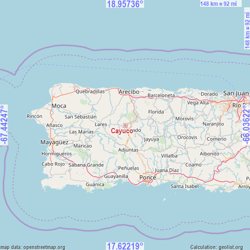
Cayuco GPS coordinates[2]
18° 17' 27.816" North, 66° 44' 21.624" West
| Map corner | latitude | longitude |
|---|---|---|
| Upper-left | 18.95736°, | -67.44247° |
| Center: | 18.29106°, | -66.73934° |
| Lower-right: | 17.62219°, | -66.03622° |
| Map W x H: | 148.5×148.5 km | = 92.3×92.3mi |
| max Lat: | 18.50078° ⇑43.6% North |
| Cayuco: | 18.29106° |
| min Lat: | ⇓56.4% South 17.95358° |
| min Long | Cayuco | max Long |
| -67.2499° | -66.73934° | -65.30099° |
| W 25.8%⇐ | ⇒74.2% E |
Elevation
Elevation of Cayuco is 431 m = 1414 ft, and this is 330.5 m = 1084 ft above average elevation for this country.
| Max E: |
655 m = 2149 ft | 5.8% |
| Cayuco | 431 m 1414 ft | |
| Avg. | 100.5 m = 330 ft | |
Min E: |
1 m = 3 ft | 94.2% |
See also: Puerto Rico elevation on elevation.city.
Geographical zone
Cayuco is located in North Torrid zone (between Equator and Tropic of Cancer). Distance of this Northern Tropic circle is 572.1 km =355.5 mi to North.| Distance of | km | miles | from Cayuco |
|---|---|---|---|
| North Pole | 7973.3 | 4954.4 | to North |
| Arctic Circle | 5367.4 | 3335.1 | to North |
| Tropic Cancer | 572.1 | 355.5 | to North |
| Equator | 2033.8 | 1263.7 | to South |


Nearby cities:
15 places around Cayuco: (largest is in red/bold)
• Adjuntas
14.4 km =8.9 mi,  172°
172°
• Animas
20.4 km =12.7 mi,  32°
32°
• Arecibo
20.3 km =12.6 mi,  7°
7°
• Bajadero
16.2 km =10.1 mi,  21°
21°
• Corcovado
19 km =11.8 mi,  348°
348°
• Estancias de Florida
19.8 km =12.3 mi,  64°
64°
• Florida
20.4 km =12.7 mi,  67°
67°
• Jayuya
17.6 km =10.9 mi,  117°
117°
• Juncal
19.1 km =11.9 mi,  277°
277°
• La Alianza
18.7 km =11.6 mi,  50°
50°
• Lares
14.6 km =9.1 mi,  271°
271°
• Quebrada
12.2 km =7.6 mi,  306°
306°
• Rafael Capo
13.7 km =8.5 mi,  340°
340°
• Rafael Gonzalez
16 km =9.9 mi, 341°
• Utuado
5 km =3.1 mi, 124°
Sources, notices
• [Note1] Compared only with cities in Puerto Rico existing in our database
• [Src1] Map data: © OpenStreetMap contributors (CC-BY-SA)
• [Src2] Other city data from geonames.org with taken over terms of usage.
• [Src3] Geographical zone / Annual Mean Temperature by Robert A. Rohde @ Wikipedia
