Utuado geodata
Utuado is a seat of a first-order administrative division; located in Puerto Rico in America/Puerto_Rico (GMT-4) time zone. With population of 9,844 people, there are 31 cities with bigger population in this country. Compared to other cities in Puerto Rico, 53.3% of cities are located further ↓South; 72% of cities are located further →East and 79.6% of cities have lower elevation than Utuado. Note1


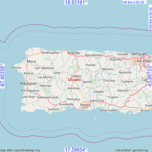
Utuado GPS coordinates[2]
18° 15' 55.836" North, 66° 42' 1.62" West
| Map corner | latitude | longitude |
|---|---|---|
| Upper-left | 18.93191°, | -67.40358° |
| Center: | 18.26551°, | -66.70045° |
| Lower-right: | 17.59654°, | -65.99733° |
| Map W x H: | 148.5×148.5 km | = 92.3×92.3mi |
| max Lat: | 18.50078° ⇑46.7% North |
| Utuado: | 18.26551° |
| min Lat: | ⇓53.3% South 17.95358° |
| min Long | Utuado | max Long |
| -67.2499° | -66.70045° | -65.30099° |
| W 28%⇐ | ⇒72% E |
Elevation
Elevation of Utuado is 145 m = 476 ft, and this is 44.5 m = 146 ft above average elevation for this country.
| Max E: |
655 m = 2149 ft | 20.4% |
| Utuado | 145 m 476 ft | |
| Avg. | 100.5 m = 330 ft | |
Min E: |
1 m = 3 ft | 79.6% |
See also: Puerto Rico elevation on elevation.city.
Geographical zone
Utuado is located in North Torrid zone (between Equator and Tropic of Cancer). Distance of this Northern Tropic circle is 575 km =357.3 mi to North.| Distance of | km | miles | from Utuado |
|---|---|---|---|
| North Pole | 7976.1 | 4956.1 | to North |
| Arctic Circle | 5370.2 | 3336.9 | to North |
| Tropic Cancer | 575 | 357.3 | to North |
| Equator | 2030.9 | 1261.9 | to South |


Nearby cities:
15 places around Utuado: (largest is in red/bold)
• Adjuntas
11.7 km =7.3 mi,  191°
191°
• Animas
21.2 km =13.2 mi,  19°
19°
• Bajadero
18 km =11.2 mi,  5°
5°
• Bufalo
21.7 km =13.5 mi,  38°
38°
• Cayuco
5 km =3.1 mi,  304°
304°
• Estancias de Florida
17.8 km =11.1 mi,  50°
50°
• Florida
18.2 km =11.3 mi, 53°
• Jayuya
12.6 km =7.8 mi,  114°
114°
• La Alianza
18 km =11.2 mi, 35°
• Lares
18.9 km =11.7 mi,  279°
279°
• Pajonal
20 km =12.4 mi, 49°
• Quebrada
17.2 km =10.7 mi,  306°
306°
• Rafael Capo
18 km =11.2 mi,  331°
331°
• Rafael Gonzalez
20.2 km =12.6 mi, 333°
• Sabana Hoyos
20.8 km =12.9 mi,  26°
26°
Sources, notices
• [Note1] Compared only with cities in Puerto Rico existing in our database
• [Src1] Map data: © OpenStreetMap contributors (CC-BY-SA)
• [Src2] Other city data from geonames.org with taken over terms of usage.
• [Src3] Geographical zone / Annual Mean Temperature by Robert A. Rohde @ Wikipedia
