Moca geodata
Moca is a seat of a first-order administrative division; located in Puerto Rico in America/Puerto_Rico (GMT-4) time zone. With population of 4,964 people, there are 71 cities with bigger population in this country. Compared to other cities in Puerto Rico, 76% of cities are located further ↓South; 92.4% of cities are located further →East and 50.7% of cities have lower elevation than Moca. Note1


Moca GPS coordinates[2]
18° 23' 40.812" North, 67° 6' 47.664" West
| Map corner | latitude | longitude |
|---|---|---|
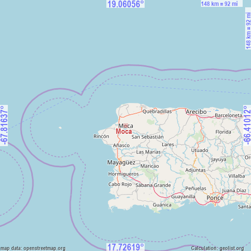
| Upper-left | 19.06056°, | -67.81637° |
| Center: | 18.39467°, | -67.11324° |
| Lower-right: | 17.72619°, | -66.41012° |
| Map W x H: | 148.4×148.4 km | = 92.2×92.2mi |
| max Lat: | 18.50078° ⇑24% North |
| Moca: | 18.39467° |
| min Lat: | ⇓76% South 17.95358° |
| min Long | Moca | max Long |
| -67.2499° | -67.11324° | -65.30099° |
| W 7.6%⇐ | ⇒92.4% E |
Elevation
Elevation of Moca is 49 m = 161 ft, and this is 51.5 m = 169 ft below average elevation for this country.
| Max E: |
655 m = 2149 ft | 49.3% |
| Avg. | 100.5 m = 330 ft | |
| Moca | 49 m = 161 ft | |
Min E: |
1 m = 3 ft | 50.7% |
See also: Puerto Rico elevation on elevation.city.
Geographical zone
Moca is located in North Torrid zone (between Equator and Tropic of Cancer). Distance of this Northern Tropic circle is 560.6 km =348.3 mi to North.| Distance of | km | miles | from Moca |
|---|---|---|---|
| North Pole | 7961.8 | 4947.2 | to North |
| Arctic Circle | 5355.9 | 3328 | to North |
| Tropic Cancer | 560.6 | 348.3 | to North |
| Equator | 2045.3 | 1270.9 | to South |


Nearby cities:
15 places around Moca: (largest is in red/bold)
• Aceitunas
7.4 km =4.6 mi,  43°
43°
• Aguada
8.1 km =5 mi,  257°
257°
• Aguadilla
5.6 km =3.5 mi,  310°
310°
• Añasco
12.8 km =8 mi,  192°
192°
• Caban
5.9 km =3.7 mi,  336°
336°
• Espino
13.2 km =8.2 mi,  182°
182°
• Hato Arriba
9.4 km =5.8 mi,  117°
117°
• Isabela
15.1 km =9.4 mi, 38°
• La Playa
14.2 km =8.8 mi,  213°
213°
• Las Marias
11.8 km =7.3 mi,  197°
197°
• Luyando
5.7 km =3.5 mi,  234°
234°
• Mora
11.4 km =7.1 mi,  48°
48°
• Rafael Hernandez
9.3 km =5.8 mi,  22°
22°
• San Antonio
11 km =6.8 mi,  8°
8°
• San Sebastián
14.5 km =9 mi, 116°
Sources, notices
• [Note1] Compared only with cities in Puerto Rico existing in our database
• [Src1] Map data: © OpenStreetMap contributors (CC-BY-SA)
• [Src2] Other city data from geonames.org with taken over terms of usage.
• [Src3] Geographical zone / Annual Mean Temperature by Robert A. Rohde @ Wikipedia
