San Sebastián geodata
San Sebastián is a seat of a first-order administrative division; located in Puerto Rico in America/Puerto_Rico (GMT-4) time zone. With population of 11,590 people, there are 28 cities with bigger population in this country. Compared to other cities in Puerto Rico, 61.3% of cities are located further ↓South; 86.2% of cities are located further →East and 65.8% of cities have lower elevation than San Sebastián. Note1


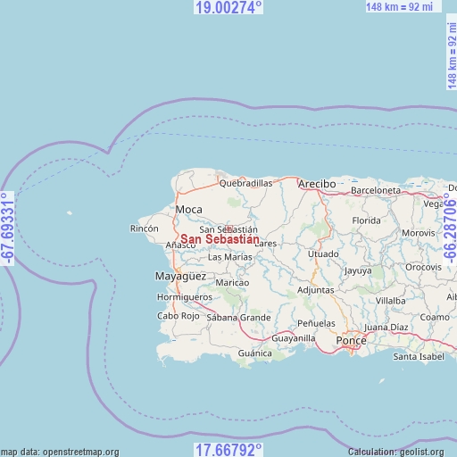
San Sebastián GPS coordinates[2]
18° 20' 11.832" North, 66° 59' 24.648" West
| Map corner | latitude | longitude |
|---|---|---|
| Upper-left | 19.00274°, | -67.69331° |
| Center: | 18.33662°, | -66.99018° |
| Lower-right: | 17.66792°, | -66.28706° |
| Map W x H: | 148.4×148.4 km | = 92.2×92.2mi |
| max Lat: | 18.50078° ⇑38.7% North |
| San Sebastián: | 18.33662° |
| min Lat: | ⇓61.3% South 17.95358° |
| min Long | San Sebastián | max Long |
| -67.2499° | -66.99018° | -65.30099° |
| W 13.8%⇐ | ⇒86.2% E |
Elevation
Elevation of San Sebastián is 83 m = 272 ft, and this is 17.5 m = 57 ft below average elevation for this country.
| Max E: |
655 m = 2149 ft | 34.2% |
| Avg. | 100.5 m = 330 ft | |
| San Sebastián | 83 m = 272 ft | |
Min E: |
1 m = 3 ft | 65.8% |
See also: Puerto Rico elevation on elevation.city.
Geographical zone
San Sebastián is located in North Torrid zone (between Equator and Tropic of Cancer). Distance of this Northern Tropic circle is 567.1 km =352.4 mi to North.| Distance of | km | miles | from San Sebastián |
|---|---|---|---|
| North Pole | 7968.2 | 4951.2 | to North |
| Arctic Circle | 5362.3 | 3332 | to North |
| Tropic Cancer | 567.1 | 352.4 | to North |
| Equator | 2038.8 | 1266.9 | to South |


Nearby cities:
15 places around San Sebastián: (largest is in red/bold)
• Aceitunas
14.2 km =8.8 mi,  326°
326°
• Añasco
16.9 km =10.5 mi,  249°
249°
• Cacao
12.4 km =7.7 mi,  26°
26°
• Espino
15.2 km =9.4 mi,  243°
243°
• Hato Arriba
5.1 km =3.2 mi,  294°
294°
• Juncal
7.9 km =4.9 mi,  108°
108°
• Lares
12.8 km =8 mi, 111°
• Las Marias
17.2 km =10.7 mi, 253°
• Las Marías
9.4 km =5.8 mi,  181°
181°
• Moca
14.5 km =9 mi,  296°
296°
• Mora
14.8 km =9.2 mi,  342°
342°
• Piedra Gorda
15.3 km =9.5 mi,  44°
44°
• Quebrada
16.8 km =10.4 mi,  82°
82°
• Quebradillas
16.2 km =10.1 mi,  19°
19°
• San Antonio
13.5 km =8.4 mi, 18°
Sources, notices
• [Note1] Compared only with cities in Puerto Rico existing in our database
• [Src1] Map data: © OpenStreetMap contributors (CC-BY-SA)
• [Src2] Other city data from geonames.org with taken over terms of usage.
• [Src3] Geographical zone / Annual Mean Temperature by Robert A. Rohde @ Wikipedia
