Aguadilla geodata
Aguadilla is a seat of a first-order administrative division; located in Puerto Rico in America/Puerto_Rico (GMT-4) time zone. With population of 16,073 people, there are 20 cities with bigger population in this country. Compared to other cities in Puerto Rico, 82.2% of cities are located further ↓South; 96.4% of cities are located further →East and 92.9% of cities have higher elevation than Aguadilla. Note1


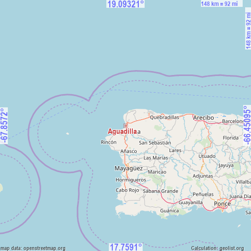
Aguadilla GPS coordinates[2]
18° 25' 38.82" North, 67° 9' 14.652" West
| Map corner | latitude | longitude |
|---|---|---|
| Upper-left | 19.09321°, | -67.8572° |
| Center: | 18.42745°, | -67.15407° |
| Lower-right: | 17.7591°, | -66.45095° |
| Map W x H: | 148.3×148.3 km | = 92.1×92.1mi |
| max Lat: | 18.50078° ⇑17.8% North |
| Aguadilla: | 18.42745° |
| min Lat: | ⇓82.2% South 17.95358° |
| min Long | Aguadilla | max Long |
| -67.2499° | -67.15407° | -65.30099° |
| W 3.6%⇐ | ⇒96.4% E |
Elevation
Elevation of Aguadilla is 7 m = 23 ft, and this is 93.5 m = 307 ft below average elevation for this country.
| Max E: |
655 m = 2149 ft | 92.9% |
| Avg. | 100.5 m = 330 ft | |
| Aguadilla | 7 m = 23 ft | |
Min E: |
1 m = 3 ft | 7.1% |
See also: Puerto Rico elevation on elevation.city.
Geographical zone
Aguadilla is located in North Torrid zone (between Equator and Tropic of Cancer). Distance of this Northern Tropic circle is 557 km =346.1 mi to North.| Distance of | km | miles | from Aguadilla |
|---|---|---|---|
| North Pole | 7958.1 | 4944.9 | to North |
| Arctic Circle | 5352.2 | 3325.7 | to North |
| Tropic Cancer | 557 | 346.1 | to North |
| Equator | 2048.9 | 1273.1 | to South |


Nearby cities:
15 places around Aguadilla: (largest is in red/bold)
• Aceitunas
9.6 km =6 mi,  79°
79°
• Aguada
6.4 km =4 mi,  214°
214°
• Añasco
16.2 km =10.1 mi,  174°
174°
• Caban
2.6 km =1.6 mi,  47°
47°
• Hato Arriba
15 km =9.3 mi,  122°
122°
• Isabela
15.9 km =9.9 mi,  59°
59°
• La Playa
15.9 km =9.9 mi,  192°
192°
• Las Marias
14.9 km =9.3 mi,  176°
176°
• Luyando
7 km =4.3 mi, 182°
• Moca
5.6 km =3.5 mi,  130°
130°
• Mora
13.4 km =8.3 mi,  72°
72°
• Rafael Hernandez
9.3 km =5.8 mi, 58°
• Rincón
14 km =8.7 mi,  226°
226°
• San Antonio
9.3 km =5.8 mi,  39°
39°
• Stella
15.3 km =9.5 mi,  219°
219°
Sources, notices
• [Note1] Compared only with cities in Puerto Rico existing in our database
• [Src1] Map data: © OpenStreetMap contributors (CC-BY-SA)
• [Src2] Other city data from geonames.org with taken over terms of usage.
• [Src3] Geographical zone / Annual Mean Temperature by Robert A. Rohde @ Wikipedia
