Bairoa geodata
Bairoa (Caguas) is a populated place; located in Puerto Rico in America/Puerto_Rico (GMT-4) time zone. With population of 2,365 people, there are 120 cities with bigger population in this country. Compared to other cities in Puerto Rico, 52.4% of cities are located further ↓South; 74.2% of cities are located further ←West and 56.4% of cities have lower elevation than Bairoa. Note1


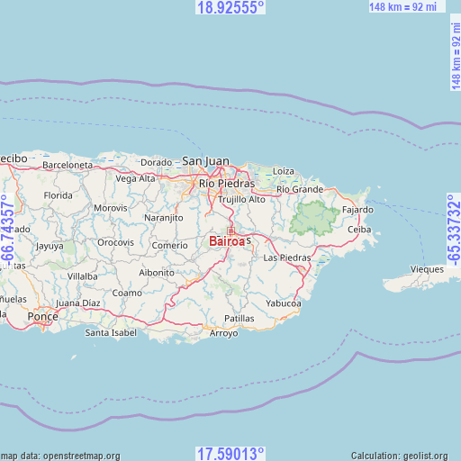
Bairoa GPS coordinates[2]
18° 15' 32.832" North, 66° 2' 25.584" West
| Map corner | latitude | longitude |
|---|---|---|
| Upper-left | 18.92555°, | -66.74357° |
| Center: | 18.25912°, | -66.04044° |
| Lower-right: | 17.59013°, | -65.33732° |
| Map W x H: | 148.5×148.5 km | = 92.3×92.3mi |
| max Lat: | 18.50078° ⇑47.6% North |
| Bairoa: | 18.25912° |
| min Lat: | ⇓52.4% South 17.95358° |
| min Long | Bairoa | max Long |
| -67.2499° | -66.04044° | -65.30099° |
| W 74.2%⇐ | ⇒25.8% E |
Elevation
Elevation of Bairoa is 64 m = 210 ft, and this is 36.5 m = 120 ft below average elevation for this country.
| Max E: |
655 m = 2149 ft | 43.6% |
| Avg. | 100.5 m = 330 ft | |
| Bairoa | 64 m = 210 ft | |
Min E: |
1 m = 3 ft | 56.4% |
See also: Puerto Rico elevation on elevation.city.
Geographical zone
Bairoa is located in North Torrid zone (between Equator and Tropic of Cancer). Distance of this Northern Tropic circle is 575.7 km =357.7 mi to North.| Distance of | km | miles | from Bairoa |
|---|---|---|---|
| North Pole | 7976.8 | 4956.6 | to North |
| Arctic Circle | 5371 | 3337.4 | to North |
| Tropic Cancer | 575.7 | 357.7 | to North |
| Equator | 2030.2 | 1261.5 | to South |


Nearby cities:
15 places around Bairoa: (largest is in red/bold)
• Aguas Buenas
6.6 km =4.1 mi,  267°
267°
• Bayamon
11.9 km =7.4 mi,  220°
220°
• Caguas
2.9 km =1.8 mi,  197°
197°
• Carolina
16.1 km =10 mi,  32°
32°
• Celada
8 km =5 mi,  79°
79°
• Cidra
15.8 km =9.8 mi,  234°
234°
• Guaynabo
13.2 km =8.2 mi,  325°
325°
• Gurabo
7.1 km =4.4 mi,  94°
94°
• Jagual
11.8 km =7.3 mi,  156°
156°
• Juncos
13.1 km =8.1 mi,  105°
105°
• Lomas
13.9 km =8.6 mi, 85°
• San Lorenzo
11.4 km =7.1 mi,  132°
132°
• Santa Clara
10.4 km =6.5 mi,  244°
244°
• Sumidero
10.4 km =6.5 mi, 244°
• Trujillo Alto
11.2 km =7 mi,  18°
18°
Sources, notices
• [Note1] Compared only with cities in Puerto Rico existing in our database
• [Src1] Map data: © OpenStreetMap contributors (CC-BY-SA)
• [Src2] Other city data from geonames.org with taken over terms of usage.
• [Src3] Geographical zone / Annual Mean Temperature by Robert A. Rohde @ Wikipedia
