Juncos geodata
Juncos is a seat of a first-order administrative division; located in Puerto Rico in America/Puerto_Rico (GMT-4) time zone. With population of 8,905 people, there are 40 cities with bigger population in this country. Compared to other cities in Puerto Rico, 52% of cities are located further ↑North; 79.1% of cities are located further ←West and 58.2% of cities have lower elevation than Juncos. Note1


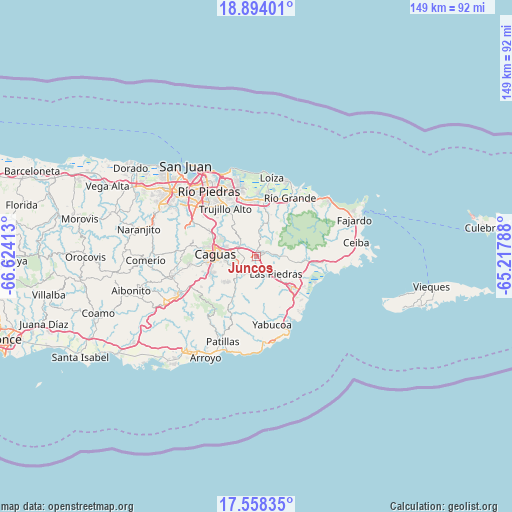
Juncos GPS coordinates[2]
18° 13' 38.856" North, 65° 55' 15.6" West
| Map corner | latitude | longitude |
|---|---|---|
| Upper-left | 18.89401°, | -66.62413° |
| Center: | 18.22746°, | -65.921° |
| Lower-right: | 17.55835°, | -65.21788° |
| Map W x H: | 148.5×148.5 km | = 92.3×92.3mi |
| max Lat: | 18.50078° ⇑52% North |
| Juncos: | 18.22746° |
| min Lat: | ⇓48% South 17.95358° |
| min Long | Juncos | max Long |
| -67.2499° | -65.921° | -65.30099° |
| W 79.1%⇐ | ⇒20.9% E |
Elevation
Elevation of Juncos is 68 m = 223 ft, and this is 32.5 m = 107 ft below average elevation for this country.
| Max E: |
655 m = 2149 ft | 41.8% |
| Avg. | 100.5 m = 330 ft | |
| Juncos | 68 m = 223 ft | |
Min E: |
1 m = 3 ft | 58.2% |
See also: Puerto Rico elevation on elevation.city.
Geographical zone
Juncos is located in North Torrid zone (between Equator and Tropic of Cancer). Distance of this Northern Tropic circle is 579.2 km =359.9 mi to North.| Distance of | km | miles | from Juncos |
|---|---|---|---|
| North Pole | 7980.4 | 4958.8 | to North |
| Arctic Circle | 5374.5 | 3339.6 | to North |
| Tropic Cancer | 579.2 | 359.9 | to North |
| Equator | 2026.7 | 1259.3 | to South |


Nearby cities:
15 places around Juncos: (largest is in red/bold)
• Antón Ruiz
12.8 km =8 mi,  111°
111°
• Benitez
6.8 km =4.2 mi,  40°
40°
• Boqueron
8 km =5 mi, 106°
• Campo Rico
12.4 km =7.7 mi,  11°
11°
• Celada
6.8 km =4.2 mi,  315°
315°
• El Mangó
4.4 km =2.7 mi,  80°
80°
• Gurabo
6.2 km =3.9 mi,  298°
298°
• Humacao
13.1 km =8.1 mi,  131°
131°
• Jagual
10.7 km =6.6 mi,  227°
227°
• La Fermina
9.2 km =5.7 mi, 129°
• Las Piedras
7.6 km =4.7 mi, 130°
• Lomas
4.7 km =2.9 mi,  15°
15°
• Peña Pobre
10.5 km =6.5 mi,  97°
97°
• Pueblito del Rio
6.1 km =3.8 mi,  89°
89°
• San Lorenzo
6 km =3.7 mi,  224°
224°
Sources, notices
• [Note1] Compared only with cities in Puerto Rico existing in our database
• [Src1] Map data: © OpenStreetMap contributors (CC-BY-SA)
• [Src2] Other city data from geonames.org with taken over terms of usage.
• [Src3] Geographical zone / Annual Mean Temperature by Robert A. Rohde @ Wikipedia
