Caguas geodata
Caguas is a seat of a first-order administrative division; located in Puerto Rico in America/Puerto_Rico (GMT-4) time zone. With population of 86,804 people, there are 4 cities with bigger population in this country. Compared to other cities in Puerto Rico, 50.7% of cities are located further ↑North; 73.8% of cities are located further ←West and 57.8% of cities have lower elevation than Caguas. Note1


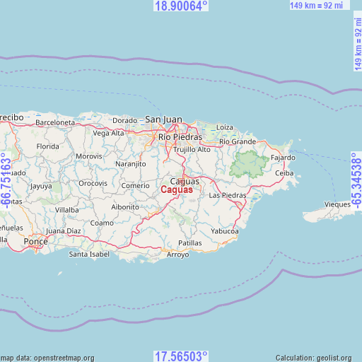
Caguas GPS coordinates[2]
18° 14' 2.832" North, 66° 2' 54.6" West
| Map corner | latitude | longitude |
|---|---|---|
| Upper-left | 18.90064°, | -66.75163° |
| Center: | 18.23412°, | -66.0485° |
| Lower-right: | 17.56503°, | -65.34538° |
| Map W x H: | 148.5×148.5 km | = 92.3×92.3mi |
| max Lat: | 18.50078° ⇑50.7% North |
| Caguas: | 18.23412° |
| min Lat: | ⇓49.3% South 17.95358° |
| min Long | Caguas | max Long |
| -67.2499° | -66.0485° | -65.30099° |
| W 73.8%⇐ | ⇒26.2% E |
Elevation
Elevation of Caguas is 65 m = 213 ft, and this is 35.5 m = 116 ft below average elevation for this country.
| Max E: |
655 m = 2149 ft | 42.2% |
| Avg. | 100.5 m = 330 ft | |
| Caguas | 65 m = 213 ft | |
Min E: |
1 m = 3 ft | 57.8% |
See also: Caguas elevation on elevation.city.
Geographical zone
Caguas is located in North Torrid zone (between Equator and Tropic of Cancer). Distance of this Northern Tropic circle is 578.5 km =359.5 mi to North.| Distance of | km | miles | from Caguas |
|---|---|---|---|
| North Pole | 7979.6 | 4958.3 | to North |
| Arctic Circle | 5373.7 | 3339.1 | to North |
| Tropic Cancer | 578.5 | 359.5 | to North |
| Equator | 2027.4 | 1259.8 | to South |


Nearby cities:
15 places around Caguas: (largest is in red/bold)
• Aguas Buenas
6.3 km =3.9 mi,  293°
293°
• Bairoa
2.9 km =1.8 mi,  17°
17°
• Bayamon
9.3 km =5.8 mi,  227°
227°
• Celada
9.7 km =6 mi,  64°
64°
• Cidra
13.6 km =8.5 mi,  241°
241°
• G. L. Garcia
13.2 km =8.2 mi,  206°
206°
• Guaynabo
15.2 km =9.4 mi,  334°
334°
• Gurabo
8.3 km =5.2 mi,  74°
74°
• Jagual
9.8 km =6.1 mi,  145°
145°
• Juncos
13.5 km =8.4 mi,  93°
93°
• Lomas
15.2 km =9.4 mi,  75°
75°
• San Lorenzo
10.5 km =6.5 mi,  118°
118°
• Santa Clara
8.7 km =5.4 mi,  258°
258°
• Sumidero
8.7 km =5.4 mi, 258°
• Trujillo Alto
14.1 km =8.8 mi, 17°
Sources, notices
• [Note1] Compared only with cities in Puerto Rico existing in our database
• [Src1] Map data: © OpenStreetMap contributors (CC-BY-SA)
• [Src2] Other city data from geonames.org with taken over terms of usage.
• [Src3] Geographical zone / Annual Mean Temperature by Robert A. Rohde @ Wikipedia
