Jagual geodata
Jagual (San Lorenzo) is a populated place; located in Puerto Rico in America/Puerto_Rico (GMT-4) time zone. With population of 1,402 people, there are 183 cities with bigger population in this country. Compared to other cities in Puerto Rico, 62.2% of cities are located further ↑North; 76% of cities are located further ←West and 87.6% of cities have lower elevation than Jagual. Note1


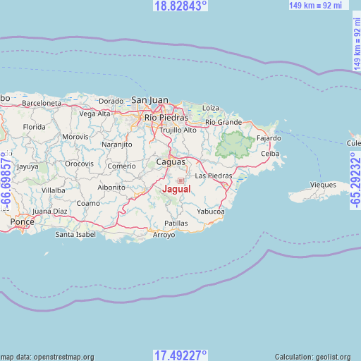
Jagual GPS coordinates[2]
18° 9' 41.868" North, 65° 59' 43.584" West
| Map corner | latitude | longitude |
|---|---|---|
| Upper-left | 18.82843°, | -66.69857° |
| Center: | 18.16163°, | -65.99544° |
| Lower-right: | 17.49227°, | -65.29232° |
| Map W x H: | 148.6×148.6 km | = 92.3×92.3mi |
| max Lat: | 18.50078° ⇑62.2% North |
| Jagual: | 18.16163° |
| min Lat: | ⇓37.8% South 17.95358° |
| min Long | Jagual | max Long |
| -67.2499° | -65.99544° | -65.30099° |
| W 76%⇐ | ⇒24% E |
Elevation
Elevation of Jagual is 208 m = 682 ft, and this is 107.5 m = 353 ft above average elevation for this country.
| Max E: |
655 m = 2149 ft | 12.4% |
| Jagual | 208 m 682 ft | |
| Avg. | 100.5 m = 330 ft | |
Min E: |
1 m = 3 ft | 87.6% |
See also: Puerto Rico elevation on elevation.city.
Geographical zone
Jagual is located in North Torrid zone (between Equator and Tropic of Cancer). Distance of this Northern Tropic circle is 586.5 km =364.4 mi to North.| Distance of | km | miles | from Jagual |
|---|---|---|---|
| North Pole | 7987.7 | 4963.3 | to North |
| Arctic Circle | 5381.8 | 3344.1 | to North |
| Tropic Cancer | 586.5 | 364.4 | to North |
| Equator | 2019.4 | 1254.8 | to South |


Nearby cities:
15 places around Jagual: (largest is in red/bold)
• Bairoa
11.8 km =7.3 mi,  336°
336°
• Bayamon
12.6 km =7.8 mi,  278°
278°
• Caguas
9.8 km =6.1 mi,  325°
325°
• Celada
12.6 km =7.8 mi,  14°
14°
• El Mangó
14.7 km =9.1 mi,  56°
56°
• G. L. Garcia
12.1 km =7.5 mi,  251°
251°
• Gurabo
10.6 km =6.6 mi, 12°
• Juncos
10.7 km =6.6 mi,  47°
47°
• La Fermina
15.1 km =9.4 mi,  84°
84°
• Las Piedras
13.9 km =8.6 mi, 80°
• Lomas
15 km =9.3 mi,  37°
37°
• Martorell
14 km =8.7 mi,  132°
132°
• Rosa Sanchez
14.1 km =8.8 mi,  142°
142°
• San Lorenzo
4.8 km =3 mi, 49°
• Santa Clara
15.4 km =9.6 mi,  294°
294°
Sources, notices
• [Note1] Compared only with cities in Puerto Rico existing in our database
• [Src1] Map data: © OpenStreetMap contributors (CC-BY-SA)
• [Src2] Other city data from geonames.org with taken over terms of usage.
• [Src3] Geographical zone / Annual Mean Temperature by Robert A. Rohde @ Wikipedia
